Appomattox geodata
Appomattox (Virginia) is a seat of a second-order administrative division; located in United States in America/New_York (GMT-4) time zone. With population of 1,759 people, there are 12706 cities with bigger population in this country. Compared to other cities in United States, 64.6% of cities are located further ↑North; 76.2% of cities are located further ←West and 63.9% of cities have lower elevation than Appomattox. Note1


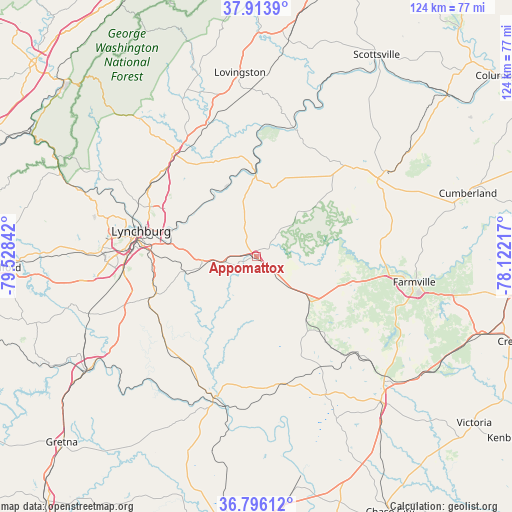
Appomattox GPS coordinates[2]
37° 21' 25.524" North, 78° 49' 31.044" West
| Map corner | latitude | longitude |
|---|---|---|
| Upper-left | 37.9139°, | -79.52842° |
| Center: | 37.35709°, | -78.82529° |
| Lower-right: | 36.79612°, | -78.12217° |
| Map W x H: | 124.3×124.3 km | = 77.2×77.2mi |
| max Lat: | 71.29058° ⇑64.6% North |
| Appomattox: | 37.35709° |
| min Lat: | ⇓35.4% South 19.06759° |
| min Long | Appomattox | max Long |
| -171.73463° | -78.82529° | -66.98998° |
| W 76.2%⇐ | ⇒23.8% E |
Elevation
Elevation of Appomattox is 257 m = 843 ft, and this is 37.8 m = 124 ft below average elevation for this country.
| Max E: |
3189 m = 10463 ft | 36.1% |
| Avg. | 294.8 m = 967 ft | |
| Appomattox | 257 m = 843 ft | |
Min E: |
-60 m = -197 ft | 63.9% |
See also: United States elevation on elevation.city.
Geographical zone
Appomattox is located in North temperate zone (between Tropic of Cancer and the Arctic Circle). Distance of this Northern Tropic circle is 1547.8 km =961.8 mi to South.| Distance of | km | miles | from Appomattox |
|---|---|---|---|
| North Pole | 5853.3 | 3637.1 | to North |
| Arctic Circle | 3247.5 | 2017.9 | to North |
| Tropic Cancer | 1547.8 | 961.8 | to South |
| Equator | 4153.7 | 2581 | to South |


Nearby cities:
15 places around Appomattox: (largest is in red/bold)
• Amherst
32.3 km =20.1 mi,  321°
321°
• Arrington
37 km =23 mi,  349°
349°
• Brookneal
35.7 km =22.2 mi,  197°
197°
• Buckingham
32.1 km =19.9 mi,  47°
47°
• Charlotte Court House
37.3 km =23.2 mi,  153°
153°
• Concord
13.3 km =8.3 mi,  263°
263°
• Farmville
38.8 km =24.1 mi,  99°
99°
• Forest
41.1 km =25.5 mi,  271°
271°
• Hampden Sydney
34.8 km =21.6 mi,  111°
111°
• Lynchburg
28.7 km =17.8 mi,  282°
282°
• Madison Heights
27.6 km =17.1 mi,  287°
287°
• Rustburg
26 km =16.2 mi,  249°
249°
• Shipman
40.8 km =25.4 mi,  358°
358°
• Timberlake
38.4 km =23.9 mi, 263°
• West Lynchburg
31.6 km =19.6 mi, 279°
Sources, notices
• [Note1] Compared only with cities in United States existing in our database
• [Src1] Map data: © OpenStreetMap contributors (CC-BY-SA)
• [Src2] Other city data from geonames.org with taken over terms of usage.
• [Src3] Geographical zone / Annual Mean Temperature by Robert A. Rohde @ Wikipedia
