Chatham geodata
Chatham (Virginia) is a seat of a second-order administrative division; located in United States in America/New_York (GMT-4) time zone. With population of 1,481 people, there are 13746 cities with bigger population in this country. Compared to other cities in United States, 66.8% of cities are located further ↑North; 75% of cities are located further ←West and 56.4% of cities have lower elevation than Chatham. Note1


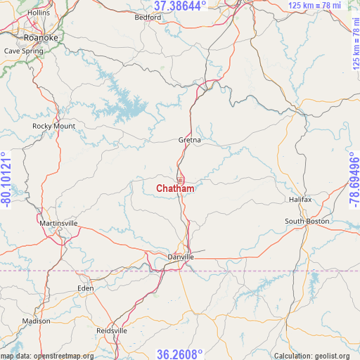
Chatham GPS coordinates[2]
36° 49' 32.484" North, 79° 23' 53.088" West
| Map corner | latitude | longitude |
|---|---|---|
| Upper-left | 37.38644°, | -80.10121° |
| Center: | 36.82569°, | -79.39808° |
| Lower-right: | 36.2608°, | -78.69496° |
| Map W x H: | 125.2×125.2 km | = 77.8×77.8mi |
| max Lat: | 71.29058° ⇑66.8% North |
| Chatham: | 36.82569° |
| min Lat: | ⇓33.2% South 19.06759° |
| min Long | Chatham | max Long |
| -171.73463° | -79.39808° | -66.98998° |
| W 75%⇐ | ⇒25% E |
Elevation
Elevation of Chatham is 224 m = 735 ft, and this is 70.8 m = 232 ft below average elevation for this country.
| Max E: |
3189 m = 10463 ft | 43.6% |
| Avg. | 294.8 m = 967 ft | |
| Chatham | 224 m = 735 ft | |
Min E: |
-60 m = -197 ft | 56.4% |
See also: United States elevation on elevation.city.
Geographical zone
Chatham is located in North temperate zone (between Tropic of Cancer and the Arctic Circle). Distance of this Northern Tropic circle is 1488.7 km =925 mi to South.| Distance of | km | miles | from Chatham |
|---|---|---|---|
| North Pole | 5912.4 | 3673.8 | to North |
| Arctic Circle | 3306.5 | 2054.6 | to North |
| Tropic Cancer | 1488.7 | 925 | to South |
| Equator | 4094.6 | 2544.3 | to South |


Nearby cities:
15 places around Chatham: (largest is in red/bold)
• Altavista
33.3 km =20.7 mi,  17°
17°
• Blairs
16.4 km =10.2 mi,  172°
172°
• Chatmoss
41.4 km =25.7 mi,  243°
243°
• Danville
26.7 km =16.6 mi,  179°
179°
• Gretna
14.7 km =9.1 mi,  13°
13°
• Halifax
42.3 km =26.3 mi,  99°
99°
• Hurt
31 km =19.3 mi, 16°
• Laurel Park
39 km =24.2 mi,  246°
246°
• Motley
27.6 km =17.1 mi, 10°
• Mount Hermon
16.5 km =10.3 mi,  187°
187°
• Mountain Road
37.3 km =23.2 mi, 101°
• North Shore
36.7 km =22.8 mi,  320°
320°
• Penhook
26.9 km =16.7 mi,  310°
310°
• Ridgeway
19.7 km =12.2 mi,  337°
337°
• Union Hall
33.4 km =20.8 mi, 309°
Sources, notices
• [Note1] Compared only with cities in United States existing in our database
• [Src1] Map data: © OpenStreetMap contributors (CC-BY-SA)
• [Src2] Other city data from geonames.org with taken over terms of usage.
• [Src3] Geographical zone / Annual Mean Temperature by Robert A. Rohde @ Wikipedia
