Penhook geodata
Penhook (Virginia) is a populated place; located in United States in America/New_York (GMT-4) time zone. With population of 801 people, there are 17804 cities with bigger population in this country. Compared to other cities in United States, 66.2% of cities are located further ↑North; 74.6% of cities are located further ←West and 72.8% of cities have lower elevation than Penhook. Note1


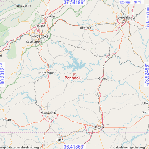
Penhook GPS coordinates[2]
36° 58' 56.532" North, 79° 37' 41.088" West
| Map corner | latitude | longitude |
|---|---|---|
| Upper-left | 37.54196°, | -80.33121° |
| Center: | 36.98237°, | -79.62808° |
| Lower-right: | 36.41863°, | -78.92496° |
| Map W x H: | 124.9×124.9 km | = 77.6×77.6mi |
| max Lat: | 71.29058° ⇑66.2% North |
| Penhook: | 36.98237° |
| min Lat: | ⇓33.8% South 19.06759° |
| min Long | Penhook | max Long |
| -171.73463° | -79.62808° | -66.98998° |
| W 74.6%⇐ | ⇒25.4% E |
Elevation
Elevation of Penhook is 300 m = 984 ft, and this is 5.2 m = 17 ft above average elevation for this country.
| Max E: |
3189 m = 10463 ft | 27.2% |
| Penhook | 300 m 984 ft | |
| Avg. | 294.8 m = 967 ft | |
Min E: |
-60 m = -197 ft | 72.8% |
See also: United States elevation on elevation.city.
Geographical zone
Penhook is located in North temperate zone (between Tropic of Cancer and the Arctic Circle). Distance of this Northern Tropic circle is 1506.1 km =935.8 mi to South.| Distance of | km | miles | from Penhook |
|---|---|---|---|
| North Pole | 5895 | 3663 | to North |
| Arctic Circle | 3289.1 | 2043.8 | to North |
| Tropic Cancer | 1506.1 | 935.8 | to South |
| Equator | 4112.1 | 2555.1 | to South |


Nearby cities:
15 places around Penhook: (largest is in red/bold)
• Altavista
33.6 km =20.9 mi,  64°
64°
• Chatham
26.9 km =16.7 mi,  130°
130°
• Ferrum
34.9 km =21.7 mi,  259°
259°
• Gretna
24.1 km =15 mi,  97°
97°
• Henry Fork
21.6 km =13.4 mi,  265°
265°
• Hurt
31.9 km =19.8 mi,  67°
67°
• Laurel Park
36.1 km =22.4 mi,  205°
205°
• Motley
27.3 km =17 mi, 69°
• Mount Hermon
38.4 km =23.9 mi,  151°
151°
• North Shore
11.4 km =7.1 mi,  346°
346°
• Oak Level
33 km =20.5 mi,  235°
235°
• Ridgeway
13 km =8.1 mi,  86°
86°
• Rocky Mount
23.5 km =14.6 mi, 274°
• Union Hall
6.6 km =4.1 mi,  307°
307°
• Westlake Corner
16.9 km =10.5 mi,  337°
337°
Sources, notices
• [Note1] Compared only with cities in United States existing in our database
• [Src1] Map data: © OpenStreetMap contributors (CC-BY-SA)
• [Src2] Other city data from geonames.org with taken over terms of usage.
• [Src3] Geographical zone / Annual Mean Temperature by Robert A. Rohde @ Wikipedia
