Danville geodata
Danville (Virginia) is a seat of a second-order administrative division; located in United States in America/New_York (GMT-4) time zone. With population of 42,082 people, there are 1138 cities with bigger population in this country. Compared to other cities in United States, 67.8% of cities are located further ↑North; 75.1% of cities are located further ←West and 59.5% of cities have higher elevation than Danville. Note1


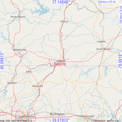
Danville GPS coordinates[2]
36° 35' 9.492" North, 79° 23' 42.072" West
| Map corner | latitude | longitude |
|---|---|---|
| Upper-left | 37.14848°, | -80.09815° |
| Center: | 36.58597°, | -79.39502° |
| Lower-right: | 36.01933°, | -78.6919° |
| Map W x H: | 125.5×125.6 km | = 78×78mi |
| max Lat: | 71.29058° ⇑67.8% North |
| Danville: | 36.58597° |
| min Lat: | ⇓32.2% South 19.06759° |
| min Long | Danville | max Long |
| -171.73463° | -79.39502° | -66.98998° |
| W 75.1%⇐ | ⇒24.9% E |
Elevation
Elevation of Danville is 157 m = 515 ft, and this is 137.8 m = 452 ft below average elevation for this country.
| Max E: |
3189 m = 10463 ft | 59.5% |
| Avg. | 294.8 m = 967 ft | |
| Danville | 157 m = 515 ft | |
Min E: |
-60 m = -197 ft | 40.5% |
See also: Danville elevation on elevation.city.
Geographical zone
Danville is located in North temperate zone (between Tropic of Cancer and the Arctic Circle). Distance of this Northern Tropic circle is 1462.1 km =908.5 mi to South.| Distance of | km | miles | from Danville |
|---|---|---|---|
| North Pole | 5939.1 | 3690.4 | to North |
| Arctic Circle | 3333.2 | 2071.2 | to North |
| Tropic Cancer | 1462.1 | 908.5 | to South |
| Equator | 4068 | 2527.7 | to South |


Nearby cities:
15 places around Danville: (largest is in red/bold)
• Blairs
10.6 km =6.6 mi,  10°
10°
• Chatham
26.7 km =16.6 mi,  359°
359°
• Chatmoss
38.1 km =23.7 mi,  281°
281°
• Cluster Springs
42.4 km =26.3 mi,  84°
84°
• Eden
34.9 km =21.7 mi,  251°
251°
• Gretna
41 km =25.5 mi,  4°
4°
• Laurel Park
37.9 km =23.5 mi,  287°
287°
• Martinsville
44.2 km =27.5 mi, 285°
• Mount Hermon
10.6 km =6.6 mi,  346°
346°
• Mountain Road
41.2 km =25.6 mi,  62°
62°
• Reidsville
35.2 km =21.9 mi,  223°
223°
• Ridgeway
41.4 km =25.7 mi,  268°
268°
• Roxboro
42.6 km =26.5 mi,  120°
120°
• Wentworth
39.7 km =24.7 mi,  238°
238°
• Yanceyville
20.9 km =13 mi,  165°
165°
Sources, notices
• [Note1] Compared only with cities in United States existing in our database
• [Src1] Map data: © OpenStreetMap contributors (CC-BY-SA)
• [Src2] Other city data from geonames.org with taken over terms of usage.
• [Src3] Geographical zone / Annual Mean Temperature by Robert A. Rohde @ Wikipedia
