Blairs geodata
Blairs (Virginia) is a populated place; located in United States in America/New_York (GMT-4) time zone. With population of 916 people, there are 16893 cities with bigger population in this country. Compared to other cities in United States, 67.4% of cities are located further ↑North; 75.1% of cities are located further ←West and 51.2% of cities have lower elevation than Blairs. Note1


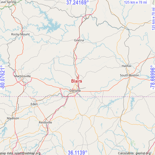
Blairs GPS coordinates[2]
36° 40' 47.496" North, 79° 22' 23.088" West
| Map corner | latitude | longitude |
|---|---|---|
| Upper-left | 37.24169°, | -80.07621° |
| Center: | 36.67986°, | -79.37308° |
| Lower-right: | 36.1139°, | -78.66996° |
| Map W x H: | 125.4×125.4 km | = 77.9×77.9mi |
| max Lat: | 71.29058° ⇑67.4% North |
| Blairs: | 36.67986° |
| min Lat: | ⇓32.6% South 19.06759° |
| min Long | Blairs | max Long |
| -171.73463° | -79.37308° | -66.98998° |
| W 75.1%⇐ | ⇒24.9% E |
Elevation
Elevation of Blairs is 203 m = 666 ft, and this is 91.8 m = 301 ft below average elevation for this country.
| Max E: |
3189 m = 10463 ft | 48.8% |
| Avg. | 294.8 m = 967 ft | |
| Blairs | 203 m = 666 ft | |
Min E: |
-60 m = -197 ft | 51.2% |
See also: United States elevation on elevation.city.
Geographical zone
Blairs is located in North temperate zone (between Tropic of Cancer and the Arctic Circle). Distance of this Northern Tropic circle is 1472.5 km =915 mi to South.| Distance of | km | miles | from Blairs |
|---|---|---|---|
| North Pole | 5928.6 | 3683.9 | to North |
| Arctic Circle | 3322.8 | 2064.7 | to North |
| Tropic Cancer | 1472.5 | 915 | to South |
| Equator | 4078.4 | 2534.2 | to South |


Nearby cities:
15 places around Blairs: (largest is in red/bold)
• Chatham
16.4 km =10.2 mi,  352°
352°
• Chatmoss
39.3 km =24.4 mi,  266°
266°
• Cluster Springs
40.8 km =25.4 mi,  99°
99°
• Danville
10.6 km =6.6 mi,  190°
190°
• Eden
41.1 km =25.5 mi,  238°
238°
• Gretna
30.5 km =19 mi,  2°
2°
• Halifax
40.8 km =25.4 mi,  76°
76°
• Laurel Park
38.1 km =23.7 mi, 271°
• Mount Hermon
4.4 km =2.7 mi, 267°
• Mountain Road
35.5 km =22.1 mi, 75°
• Penhook
40.6 km =25.2 mi,  325°
325°
• Ridgeway
35.8 km =22.2 mi,  344°
344°
• Riverdale
42.2 km =26.2 mi,  88°
88°
• South Boston
42.1 km =26.2 mi, 87°
• Yanceyville
30.8 km =19.1 mi,  173°
173°
Sources, notices
• [Note1] Compared only with cities in United States existing in our database
• [Src1] Map data: © OpenStreetMap contributors (CC-BY-SA)
• [Src2] Other city data from geonames.org with taken over terms of usage.
• [Src3] Geographical zone / Annual Mean Temperature by Robert A. Rohde @ Wikipedia
