Lovingston geodata
Lovingston (Virginia) is a seat of a second-order administrative division; located in United States in America/New_York (GMT-4) time zone. With population of 520 people, there are 20628 cities with bigger population in this country. Compared to other cities in United States, 62.9% of cities are located further ↑North; 76.1% of cities are located further ←West and 56.9% of cities have lower elevation than Lovingston. Note1


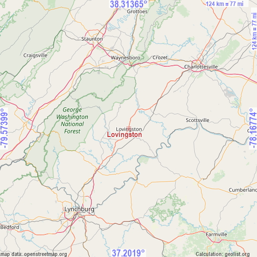
Lovingston GPS coordinates[2]
37° 45' 35.496" North, 78° 52' 15.096" West
| Map corner | latitude | longitude |
|---|---|---|
| Upper-left | 38.31365°, | -79.57399° |
| Center: | 37.75986°, | -78.87086° |
| Lower-right: | 37.2019°, | -78.16774° |
| Map W x H: | 123.6×123.6 km | = 76.8×76.8mi |
| max Lat: | 71.29058° ⇑62.9% North |
| Lovingston: | 37.75986° |
| min Lat: | ⇓37.1% South 19.06759° |
| min Long | Lovingston | max Long |
| -171.73463° | -78.87086° | -66.98998° |
| W 76.1%⇐ | ⇒23.9% E |
Elevation
Elevation of Lovingston is 226 m = 741 ft, and this is 68.8 m = 226 ft below average elevation for this country.
| Max E: |
3189 m = 10463 ft | 43.1% |
| Avg. | 294.8 m = 967 ft | |
| Lovingston | 226 m = 741 ft | |
Min E: |
-60 m = -197 ft | 56.9% |
See also: United States elevation on elevation.city.
Geographical zone
Lovingston is located in North temperate zone (between Tropic of Cancer and the Arctic Circle). Distance of this Northern Tropic circle is 1592.6 km =989.6 mi to South.| Distance of | km | miles | from Lovingston |
|---|---|---|---|
| North Pole | 5808.6 | 3609.3 | to North |
| Arctic Circle | 3202.7 | 1990.1 | to North |
| Tropic Cancer | 1592.6 | 989.6 | to South |
| Equator | 4198.5 | 2608.8 | to South |


Nearby cities:
15 places around Lovingston: (largest is in red/bold)
• Amherst
25.1 km =15.6 mi,  219°
219°
• Arrington
8.8 km =5.5 mi,  197°
197°
• Buckingham
36.3 km =22.6 mi,  130°
130°
• Crozet
37.5 km =23.3 mi,  23°
23°
• Dooms
38.8 km =24.1 mi,  1°
1°
• Esmont
24.5 km =15.2 mi,  71°
71°
• Fishersville
38.7 km =24 mi,  347°
347°
• Greenville
36.9 km =22.9 mi,  317°
317°
• Lyndhurst
30.7 km =19.1 mi, 347°
• Nellysford
14.5 km =9 mi,  359°
359°
• Scottsville
33.3 km =20.7 mi,  82°
82°
• Sherando
25.7 km =16 mi,  343°
343°
• Shipman
4.9 km =3 mi,  145°
145°
• Stuarts Draft
33.3 km =20.7 mi,  334°
334°
• Waynesboro
34.4 km =21.4 mi, 357°
Sources, notices
• [Note1] Compared only with cities in United States existing in our database
• [Src1] Map data: © OpenStreetMap contributors (CC-BY-SA)
• [Src2] Other city data from geonames.org with taken over terms of usage.
• [Src3] Geographical zone / Annual Mean Temperature by Robert A. Rohde @ Wikipedia
