Shipman geodata
Shipman (Virginia) is a populated place; located in United States in America/New_York (GMT-4) time zone. With population of 507 people, there are 20799 cities with bigger population in this country. Compared to other cities in United States, 63.1% of cities are located further ↑North; 76.2% of cities are located further ←West and 51.4% of cities have higher elevation than Shipman. Note1


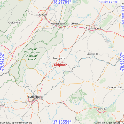
Shipman GPS coordinates[2]
37° 43' 25.5" North, 78° 50' 21.084" West
| Map corner | latitude | longitude |
|---|---|---|
| Upper-left | 38.27781°, | -79.54232° |
| Center: | 37.72375°, | -78.83919° |
| Lower-right: | 37.16551°, | -78.13607° |
| Map W x H: | 123.7×123.7 km | = 76.9×76.9mi |
| max Lat: | 71.29058° ⇑63.1% North |
| Shipman: | 37.72375° |
| min Lat: | ⇓36.9% South 19.06759° |
| min Long | Shipman | max Long |
| -171.73463° | -78.83919° | -66.98998° |
| W 76.2%⇐ | ⇒23.8% E |
Elevation
Elevation of Shipman is 193 m = 633 ft, and this is 101.8 m = 334 ft below average elevation for this country.
| Max E: |
3189 m = 10463 ft | 51.4% |
| Avg. | 294.8 m = 967 ft | |
| Shipman | 193 m = 633 ft | |
Min E: |
-60 m = -197 ft | 48.6% |
See also: United States elevation on elevation.city.
Geographical zone
Shipman is located in North temperate zone (between Tropic of Cancer and the Arctic Circle). Distance of this Northern Tropic circle is 1588.6 km =987.1 mi to South.| Distance of | km | miles | from Shipman |
|---|---|---|---|
| North Pole | 5812.6 | 3611.8 | to North |
| Arctic Circle | 3206.7 | 1992.6 | to North |
| Tropic Cancer | 1588.6 | 987.1 | to South |
| Equator | 4194.5 | 2606.3 | to South |


Nearby cities:
15 places around Shipman: (largest is in red/bold)
• Amherst
24.2 km =15 mi,  230°
230°
• Appomattox
40.8 km =25.4 mi,  178°
178°
• Arrington
7 km =4.3 mi, 230°
• Buckingham
31.6 km =19.6 mi,  127°
127°
• Crozet
40.3 km =25 mi,  17°
17°
• Esmont
23.6 km =14.7 mi,  59°
59°
• Greenville
41.7 km =25.9 mi,  318°
318°
• Lovingston
4.9 km =3 mi,  325°
325°
• Lyndhurst
35.2 km =21.9 mi,  344°
344°
• Madison Heights
41.1 km =25.5 mi,  217°
217°
• Nellysford
18.8 km =11.7 mi,  351°
351°
• Scottsville
31.3 km =19.4 mi,  74°
74°
• Sherando
30.4 km =18.9 mi, 340°
• Stuarts Draft
38.1 km =23.7 mi, 333°
• Waynesboro
38.6 km =24 mi, 353°
Sources, notices
• [Note1] Compared only with cities in United States existing in our database
• [Src1] Map data: © OpenStreetMap contributors (CC-BY-SA)
• [Src2] Other city data from geonames.org with taken over terms of usage.
• [Src3] Geographical zone / Annual Mean Temperature by Robert A. Rohde @ Wikipedia
