Warrenton geodata
Warrenton (Virginia) is a seat of a second-order administrative division; located in United States in America/New_York (GMT-4) time zone. With population of 9,897 people, there are 4492 cities with bigger population in this country. Compared to other cities in United States, 57.3% of cities are located further ↑North; 78.2% of cities are located further ←West and 50.5% of cities have higher elevation than Warrenton. Note1


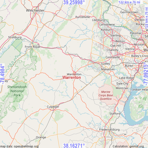
Warrenton GPS coordinates[2]
38° 42' 48.42" North, 77° 47' 42.972" West
| Map corner | latitude | longitude |
|---|---|---|
| Upper-left | 39.25998°, | -78.4984° |
| Center: | 38.71345°, | -77.79527° |
| Lower-right: | 38.16271°, | -77.09215° |
| Map W x H: | 122×122 km | = 75.8×75.8mi |
| max Lat: | 71.29058° ⇑57.3% North |
| Warrenton: | 38.71345° |
| min Lat: | ⇓42.7% South 19.06759° |
| min Long | Warrenton | max Long |
| -171.73463° | -77.79527° | -66.98998° |
| W 78.2%⇐ | ⇒21.8% E |
Elevation
Elevation of Warrenton is 196 m = 643 ft, and this is 98.8 m = 324 ft below average elevation for this country.
| Max E: |
3189 m = 10463 ft | 50.5% |
| Avg. | 294.8 m = 967 ft | |
| Warrenton | 196 m = 643 ft | |
Min E: |
-60 m = -197 ft | 49.5% |
See also: United States elevation on elevation.city.
Geographical zone
Warrenton is located in North temperate zone (between Tropic of Cancer and the Arctic Circle). Distance of this Northern Tropic circle is 1698.6 km =1055.5 mi to South.| Distance of | km | miles | from Warrenton |
|---|---|---|---|
| North Pole | 5702.5 | 3543.4 | to North |
| Arctic Circle | 3096.6 | 1924.1 | to North |
| Tropic Cancer | 1698.6 | 1055.5 | to South |
| Equator | 4304.5 | 2674.7 | to South |


Nearby cities:
15 places around Warrenton: (largest is in red/bold)
• Bealeton
16 km =9.9 mi,  170°
170°
• Bull Run
25.1 km =15.6 mi,  71°
71°
• Bull Run Mountain Estates
24.1 km =15 mi,  28°
28°
• Gainesville
18.2 km =11.3 mi,  59°
59°
• Haymarket
17.6 km =10.9 mi,  51°
51°
• Linton Hall
19.8 km =12.3 mi, 74°
• Loch Lomond
28.7 km =17.8 mi, 73°
• Manassas
28.1 km =17.5 mi,  81°
81°
• Marshall
17.7 km =11 mi,  342°
342°
• New Baltimore
8.3 km =5.2 mi,  44°
44°
• Nokesville
18.8 km =11.7 mi,  95°
95°
• Opal
10.3 km =6.4 mi,  182°
182°
• Remington
20 km =12.4 mi, 183°
• Sudley
27.3 km =17 mi, 71°
• West Gate
27 km =16.8 mi, 73°
Sources, notices
• [Note1] Compared only with cities in United States existing in our database
• [Src1] Map data: © OpenStreetMap contributors (CC-BY-SA)
• [Src2] Other city data from geonames.org with taken over terms of usage.
• [Src3] Geographical zone / Annual Mean Temperature by Robert A. Rohde @ Wikipedia
