South Windham geodata
South Windham (Connecticut) is a populated place; located in United States in America/New_York (GMT-4) time zone. With population of 1,421 people, there are 14009 cities with bigger population in this country. Compared to other cities in United States, 72.7% of cities are located further ↓South; 95.4% of cities are located further ←West and 78.4% of cities have higher elevation than South Windham. Note1


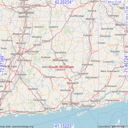
South Windham GPS coordinates[2]
41° 40' 46.344" North, 72° 10' 13.296" West
| Map corner | latitude | longitude |
|---|---|---|
| Upper-left | 42.20254°, | -72.87349° |
| Center: | 41.67954°, | -72.17036° |
| Lower-right: | 41.15225°, | -71.46724° |
| Map W x H: | 116.8×116.8 km | = 72.6×72.6mi |
| max Lat: | 71.29058° ⇑27.3% North |
| South Windham: | 41.67954° |
| min Lat: | ⇓72.7% South 19.06759° |
| min Long | South Windham | max Long |
| -171.73463° | -72.17036° | -66.98998° |
| W 95.4%⇐ | ⇒4.6% E |
Elevation
Elevation of South Windham is 54 m = 177 ft, and this is 240.8 m = 790 ft below average elevation for this country.
| Max E: |
3189 m = 10463 ft | 78.4% |
| Avg. | 294.8 m = 967 ft | |
| South Windham | 54 m = 177 ft | |
Min E: |
-60 m = -197 ft | 21.6% |
See also: United States elevation on elevation.city.
Geographical zone
South Windham is located in North temperate zone (between Tropic of Cancer and the Arctic Circle). Distance of this Northern Tropic circle is 2028.4 km =1260.4 mi to South.| Distance of | km | miles | from South Windham |
|---|---|---|---|
| North Pole | 5372.7 | 3338.4 | to North |
| Arctic Circle | 2766.8 | 1719.2 | to North |
| Tropic Cancer | 2028.4 | 1260.4 | to South |
| Equator | 4634.3 | 2879.6 | to South |


Nearby cities:
15 places around South Windham: (largest is in red/bold)
• Baltic
10 km =6.2 mi,  134°
134°
• Colchester
17.7 km =11 mi,  229°
229°
• Coventry Lake
17 km =10.6 mi,  307°
307°
• Hebron
16.4 km =10.2 mi,  261°
261°
• Jewett City
17.7 km =11 mi,  117°
117°
• Lisbon
15.6 km =9.7 mi, 122°
• Mansfield Center
9.8 km =6.1 mi,  346°
346°
• Mansfield City
10.9 km =6.8 mi,  331°
331°
• Norwich
19 km =11.8 mi,  155°
155°
• Plainfield
21.2 km =13.2 mi,  90°
90°
• Plainfield Village
20.4 km =12.7 mi, 90°
• South Coventry
15 km =9.3 mi, 312°
• Storrs
15.8 km =9.8 mi,  335°
335°
• Willimantic
4.7 km =2.9 mi,  317°
317°
• Windham
2.5 km =1.6 mi,  26°
26°
Sources, notices
• [Note1] Compared only with cities in United States existing in our database
• [Src1] Map data: © OpenStreetMap contributors (CC-BY-SA)
• [Src2] Other city data from geonames.org with taken over terms of usage.
• [Src3] Geographical zone / Annual Mean Temperature by Robert A. Rohde @ Wikipedia
