Danville geodata
Danville (Iowa) is a populated place; located in United States in America/Chicago (GMT-5) time zone. With population of 936 people, there are 16749 cities with bigger population in this country. Compared to other cities in United States, 64.2% of cities are located further ↓South; 62.7% of cities are located further →East and 55.6% of cities have lower elevation than Danville. Note1


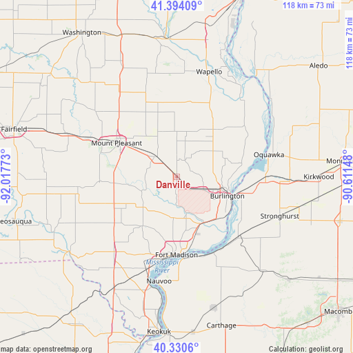
Danville GPS coordinates[2]
40° 51' 52.128" North, 91° 18' 52.56" West
| Map corner | latitude | longitude |
|---|---|---|
| Upper-left | 41.39409°, | -92.01773° |
| Center: | 40.86448°, | -91.3146° |
| Lower-right: | 40.3306°, | -90.61148° |
| Map W x H: | 118.2×118.2 km | = 73.4×73.4mi |
| max Lat: | 71.29058° ⇑35.8% North |
| Danville: | 40.86448° |
| min Lat: | ⇓64.2% South 19.06759° |
| min Long | Danville | max Long |
| -171.73463° | -91.3146° | -66.98998° |
| W 37.3%⇐ | ⇒62.7% E |
Elevation
Elevation of Danville is 221 m = 725 ft, and this is 73.8 m = 242 ft below average elevation for this country.
| Max E: |
3189 m = 10463 ft | 44.4% |
| Avg. | 294.8 m = 967 ft | |
| Danville | 221 m = 725 ft | |
Min E: |
-60 m = -197 ft | 55.6% |
See also: United States elevation on elevation.city.
Geographical zone
Danville is located in North temperate zone (between Tropic of Cancer and the Arctic Circle). Distance of this Northern Tropic circle is 1937.8 km =1204.1 mi to South.| Distance of | km | miles | from Danville |
|---|---|---|---|
| North Pole | 5463.4 | 3394.8 | to North |
| Arctic Circle | 2857.5 | 1775.6 | to North |
| Tropic Cancer | 1937.8 | 1204.1 | to South |
| Equator | 4543.7 | 2823.3 | to South |


Nearby cities:
15 places around Danville: (largest is in red/bold)
• Beaverdale
9.1 km =5.7 mi,  102°
102°
• Burlington
18.1 km =11.2 mi,  110°
110°
• Dallas City
28.3 km =17.6 mi,  153°
153°
• Donnellson
32.4 km =20.1 mi,  220°
220°
• Fort Madison
26.1 km =16.2 mi,  180°
180°
• Mediapolis
20.4 km =12.7 mi,  38°
38°
• Morning Sun
26.2 km =16.3 mi,  10°
10°
• Mount Pleasant
23.2 km =14.4 mi,  298°
298°
• Nauvoo
35.5 km =22.1 mi,  189°
189°
• New London
10 km =6.2 mi,  314°
314°
• Oquawka
31.8 km =19.8 mi,  76°
76°
• Wapello
36.9 km =22.9 mi,  17°
17°
• West Burlington
14 km =8.7 mi, 108°
• West Point
20 km =12.4 mi,  214°
214°
• Winfield
30.7 km =19.1 mi,  339°
339°
Sources, notices
• [Note1] Compared only with cities in United States existing in our database
• [Src1] Map data: © OpenStreetMap contributors (CC-BY-SA)
• [Src2] Other city data from geonames.org with taken over terms of usage.
• [Src3] Geographical zone / Annual Mean Temperature by Robert A. Rohde @ Wikipedia
