Burlington geodata
Burlington (Iowa) is a seat of a second-order administrative division; located in United States in America/Chicago (GMT-5) time zone. With population of 25,410 people, there are 1970 cities with bigger population in this country. Compared to other cities in United States, 63.3% of cities are located further ↓South; 62.3% of cities are located further →East and 52.5% of cities have higher elevation than Burlington. Note1


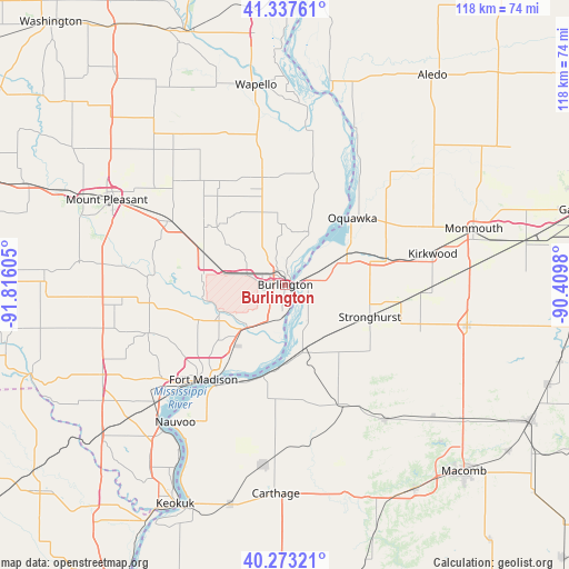
Burlington GPS coordinates[2]
40° 48' 27.144" North, 91° 6' 46.512" West
| Map corner | latitude | longitude |
|---|---|---|
| Upper-left | 41.33761°, | -91.81605° |
| Center: | 40.80754°, | -91.11292° |
| Lower-right: | 40.27321°, | -90.4098° |
| Map W x H: | 118.4×118.3 km | = 73.6×73.5mi |
| max Lat: | 71.29058° ⇑36.7% North |
| Burlington: | 40.80754° |
| min Lat: | ⇓63.3% South 19.06759° |
| min Long | Burlington | max Long |
| -171.73463° | -91.11292° | -66.98998° |
| W 37.7%⇐ | ⇒62.3% E |
Elevation
Elevation of Burlington is 189 m = 620 ft, and this is 105.8 m = 347 ft below average elevation for this country.
| Max E: |
3189 m = 10463 ft | 52.5% |
| Avg. | 294.8 m = 967 ft | |
| Burlington | 189 m = 620 ft | |
Min E: |
-60 m = -197 ft | 47.5% |
See also: United States elevation on elevation.city.
Geographical zone
Burlington is located in North temperate zone (between Tropic of Cancer and the Arctic Circle). Distance of this Northern Tropic circle is 1931.5 km =1200.2 mi to South.| Distance of | km | miles | from Burlington |
|---|---|---|---|
| North Pole | 5469.7 | 3398.7 | to North |
| Arctic Circle | 2863.8 | 1779.5 | to North |
| Tropic Cancer | 1931.5 | 1200.2 | to South |
| Equator | 4537.4 | 2819.4 | to South |


Nearby cities:
15 places around Burlington: (largest is in red/bold)
• Beaverdale
9.1 km =5.7 mi,  298°
298°
• Blandinsville
34.9 km =21.7 mi,  143°
143°
• Dallas City
19.6 km =12.2 mi,  193°
193°
• Danville
18.1 km =11.2 mi,  290°
290°
• Fort Madison
26.1 km =16.2 mi,  220°
220°
• Keithsburg
35.5 km =22.1 mi,  23°
23°
• Kirkwood
31.3 km =19.4 mi,  78°
78°
• La Harpe
27.7 km =17.2 mi,  154°
154°
• Mediapolis
22.7 km =14.1 mi,  349°
349°
• Morning Sun
34.3 km =21.3 mi,  339°
339°
• New London
27.5 km =17.1 mi, 298°
• Oquawka
19.6 km =12.2 mi,  45°
45°
• Stronghurst
18.8 km =11.7 mi,  110°
110°
• West Burlington
4.2 km =2.6 mi, 297°
• West Point
30.1 km =18.7 mi,  250°
250°
Sources, notices
• [Note1] Compared only with cities in United States existing in our database
• [Src1] Map data: © OpenStreetMap contributors (CC-BY-SA)
• [Src2] Other city data from geonames.org with taken over terms of usage.
• [Src3] Geographical zone / Annual Mean Temperature by Robert A. Rohde @ Wikipedia
