Dallas City geodata
Dallas City (Illinois) is a populated place; located in United States in America/Chicago (GMT-5) time zone. With population of 910 people, there are 16926 cities with bigger population in this country. Compared to other cities in United States, 60.6% of cities are located further ↓South; 62.4% of cities are located further →East and 57.5% of cities have higher elevation than Dallas City. Note1
Administrative division(s):
- Level 1: Illinois
- Level 2: Hancock County
- Level 3: Township of Dallas City


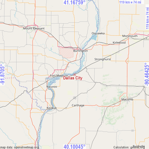
Dallas City GPS coordinates[2]
40° 38' 10.14" North, 91° 10' 2.532" West
| Map corner | latitude | longitude |
|---|---|---|
| Upper-left | 41.16759°, | -91.8705° |
| Center: | 40.63615°, | -91.16737° |
| Lower-right: | 40.10045°, | -90.46425° |
| Map W x H: | 118.7×118.7 km | = 73.8×73.8mi |
| max Lat: | 71.29058° ⇑39.4% North |
| Dallas City: | 40.63615° |
| min Lat: | ⇓60.6% South 19.06759° |
| min Long | Dallas City | max Long |
| -171.73463° | -91.16737° | -66.98998° |
| W 37.6%⇐ | ⇒62.4% E |
Elevation
Elevation of Dallas City is 168 m = 551 ft, and this is 126.8 m = 416 ft below average elevation for this country.
| Max E: |
3189 m = 10463 ft | 57.5% |
| Avg. | 294.8 m = 967 ft | |
| Dallas City | 168 m = 551 ft | |
Min E: |
-60 m = -197 ft | 42.5% |
See also: United States elevation on elevation.city.
Geographical zone
Dallas City is located in North temperate zone (between Tropic of Cancer and the Arctic Circle). Distance of this Northern Tropic circle is 1912.4 km =1188.3 mi to South.| Distance of | km | miles | from Dallas City |
|---|---|---|---|
| North Pole | 5488.7 | 3410.5 | to North |
| Arctic Circle | 2882.9 | 1791.4 | to North |
| Tropic Cancer | 1912.4 | 1188.3 | to South |
| Equator | 4518.3 | 2807.5 | to South |


Nearby cities:
15 places around Dallas City: (largest is in red/bold)
• Beaverdale
23.7 km =14.7 mi,  351°
351°
• Blandinsville
27 km =16.8 mi,  109°
109°
• Burlington
19.6 km =12.2 mi,  13°
13°
• Carthage
24.6 km =15.3 mi,  173°
173°
• Danville
28.3 km =17.6 mi,  333°
333°
• Donnellson
33.5 km =20.8 mi,  271°
271°
• Fort Madison
12.5 km =7.8 mi, 266°
• Hamilton
30.3 km =18.8 mi,  208°
208°
• Keokuk
32.3 km =20.1 mi, 214°
• La Harpe
17.7 km =11 mi, 109°
• Montrose
23.9 km =14.9 mi,  241°
241°
• Nauvoo
20.7 km =12.9 mi, 242°
• Stronghurst
25.4 km =15.8 mi,  60°
60°
• West Burlington
21 km =13 mi,  2°
2°
• West Point
25.5 km =15.8 mi,  290°
290°
Sources, notices
• [Note1] Compared only with cities in United States existing in our database
• [Src1] Map data: © OpenStreetMap contributors (CC-BY-SA)
• [Src2] Other city data from geonames.org with taken over terms of usage.
• [Src3] Geographical zone / Annual Mean Temperature by Robert A. Rohde @ Wikipedia
