West Point geodata
West Point (Iowa) is a populated place; located in United States in America/Chicago (GMT-5) time zone. With population of 962 people, there are 16552 cities with bigger population in this country. Compared to other cities in United States, 61.8% of cities are located further ↓South; 63% of cities are located further →East and 59.1% of cities have lower elevation than West Point. Note1


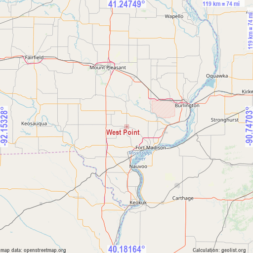
West Point GPS coordinates[2]
40° 43' 0.12" North, 91° 27' 0.54" West
| Map corner | latitude | longitude |
|---|---|---|
| Upper-left | 41.24749°, | -92.15328° |
| Center: | 40.7167°, | -91.45015° |
| Lower-right: | 40.18164°, | -90.74703° |
| Map W x H: | 118.5×118.5 km | = 73.6×73.6mi |
| max Lat: | 71.29058° ⇑38.2% North |
| West Point: | 40.7167° |
| min Lat: | ⇓61.8% South 19.06759° |
| min Long | West Point | max Long |
| -171.73463° | -91.45015° | -66.98998° |
| W 37%⇐ | ⇒63% E |
Elevation
Elevation of West Point is 236 m = 774 ft, and this is 58.8 m = 193 ft below average elevation for this country.
| Max E: |
3189 m = 10463 ft | 40.9% |
| Avg. | 294.8 m = 967 ft | |
| West Point | 236 m = 774 ft | |
Min E: |
-60 m = -197 ft | 59.1% |
See also: United States elevation on elevation.city.
Geographical zone
West Point is located in North temperate zone (between Tropic of Cancer and the Arctic Circle). Distance of this Northern Tropic circle is 1921.4 km =1193.9 mi to South.| Distance of | km | miles | from West Point |
|---|---|---|---|
| North Pole | 5479.8 | 3405 | to North |
| Arctic Circle | 2873.9 | 1785.8 | to North |
| Tropic Cancer | 1921.4 | 1193.9 | to South |
| Equator | 4527.3 | 2813.1 | to South |


Nearby cities:
15 places around West Point: (largest is in red/bold)
• Beaverdale
25 km =15.5 mi,  54°
54°
• Burlington
30.1 km =18.7 mi,  70°
70°
• Dallas City
25.5 km =15.8 mi,  110°
110°
• Danville
20 km =12.4 mi,  34°
34°
• Donnellson
12.7 km =7.9 mi,  229°
229°
• Farmington
26.1 km =16.2 mi,  251°
251°
• Fort Madison
14.9 km =9.3 mi,  130°
130°
• Hamilton
36.8 km =22.9 mi,  165°
165°
• Keokuk
35.9 km =22.3 mi, 171°
• Montrose
20.7 km =12.9 mi, 171°
• Mount Pleasant
28.9 km =18 mi,  341°
341°
• Nauvoo
19.3 km =12 mi,  163°
163°
• New London
23.8 km =14.8 mi,  10°
10°
• Wayland
37.5 km =23.3 mi,  197°
197°
• West Burlington
27.5 km =17.1 mi,  64°
64°
Sources, notices
• [Note1] Compared only with cities in United States existing in our database
• [Src1] Map data: © OpenStreetMap contributors (CC-BY-SA)
• [Src2] Other city data from geonames.org with taken over terms of usage.
• [Src3] Geographical zone / Annual Mean Temperature by Robert A. Rohde @ Wikipedia
