Pella geodata
Pella (Iowa) is a populated place; located in United States in America/Chicago (GMT-5) time zone. With population of 10,363 people, there are 4360 cities with bigger population in this country. Compared to other cities in United States, 69.8% of cities are located further ↓South; 66% of cities are located further →East and 67.4% of cities have lower elevation than Pella. Note1


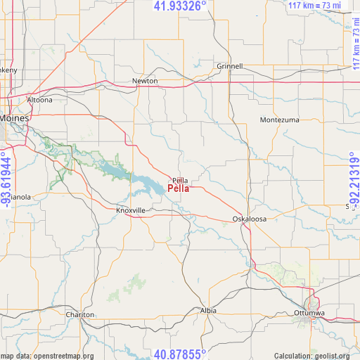
Pella GPS coordinates[2]
41° 24' 28.98" North, 92° 54' 58.716" West
| Map corner | latitude | longitude |
|---|---|---|
| Upper-left | 41.93326°, | -93.61944° |
| Center: | 41.40805°, | -92.91631° |
| Lower-right: | 40.87855°, | -92.21319° |
| Map W x H: | 117.3×117.3 km | = 72.9×72.9mi |
| max Lat: | 71.29058° ⇑30.2% North |
| Pella: | 41.40805° |
| min Lat: | ⇓69.8% South 19.06759° |
| min Long | Pella | max Long |
| -171.73463° | -92.91631° | -66.98998° |
| W 34%⇐ | ⇒66% E |
Elevation
Elevation of Pella is 273 m = 896 ft, and this is 21.8 m = 72 ft below average elevation for this country.
| Max E: |
3189 m = 10463 ft | 32.6% |
| Avg. | 294.8 m = 967 ft | |
| Pella | 273 m = 896 ft | |
Min E: |
-60 m = -197 ft | 67.4% |
See also: United States elevation on elevation.city.
Geographical zone
Pella is located in North temperate zone (between Tropic of Cancer and the Arctic Circle). Distance of this Northern Tropic circle is 1998.2 km =1241.6 mi to South.| Distance of | km | miles | from Pella |
|---|---|---|---|
| North Pole | 5402.9 | 3357.2 | to North |
| Arctic Circle | 2797 | 1738 | to North |
| Tropic Cancer | 1998.2 | 1241.6 | to South |
| Equator | 4604.1 | 2860.9 | to South |


Nearby cities:
15 places around Pella: (largest is in red/bold)
• Eddyville
36.4 km =22.6 mi,  140°
140°
• Grinnell
40.6 km =25.2 mi,  23°
23°
• Kellogg
34.5 km =21.4 mi,  1°
1°
• Knoxville
18.8 km =11.7 mi,  238°
238°
• Lovilia
30.3 km =18.8 mi,  178°
178°
• Melcher-Dallas
33.9 km =21.1 mi,  233°
233°
• Monroe
20 km =12.4 mi,  309°
309°
• Montezuma
37.9 km =23.5 mi,  58°
58°
• New Sharon
23.1 km =14.4 mi,  72°
72°
• Newton
34.2 km =21.3 mi,  341°
341°
• Oskaloosa
25.9 km =16.1 mi,  118°
118°
• Pleasantville
29.6 km =18.4 mi,  265°
265°
• Prairie City
34 km =21.1 mi, 308°
• Runnells
38.5 km =23.9 mi,  287°
287°
• Sully
19.8 km =12.3 mi, 17°
Sources, notices
• [Note1] Compared only with cities in United States existing in our database
• [Src1] Map data: © OpenStreetMap contributors (CC-BY-SA)
• [Src2] Other city data from geonames.org with taken over terms of usage.
• [Src3] Geographical zone / Annual Mean Temperature by Robert A. Rohde @ Wikipedia
