Oskaloosa geodata
Oskaloosa (Iowa) is a seat of a second-order administrative division; located in United States in America/Chicago (GMT-5) time zone. With population of 11,607 people, there are 3987 cities with bigger population in this country. Compared to other cities in United States, 68.8% of cities are located further ↓South; 65.5% of cities are located further →East and 63.7% of cities have lower elevation than Oskaloosa. Note1


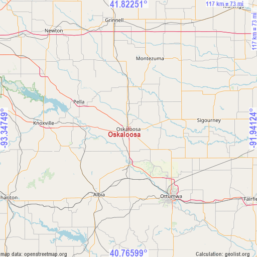
Oskaloosa GPS coordinates[2]
41° 17' 47.004" North, 92° 38' 39.696" West
| Map corner | latitude | longitude |
|---|---|---|
| Upper-left | 41.82251°, | -93.34749° |
| Center: | 41.29639°, | -92.64436° |
| Lower-right: | 40.76599°, | -91.94124° |
| Map W x H: | 117.5×117.5 km | = 73×73mi |
| max Lat: | 71.29058° ⇑31.2% North |
| Oskaloosa: | 41.29639° |
| min Lat: | ⇓68.8% South 19.06759° |
| min Long | Oskaloosa | max Long |
| -171.73463° | -92.64436° | -66.98998° |
| W 34.5%⇐ | ⇒65.5% E |
Elevation
Elevation of Oskaloosa is 256 m = 840 ft, and this is 38.8 m = 127 ft below average elevation for this country.
| Max E: |
3189 m = 10463 ft | 36.3% |
| Avg. | 294.8 m = 967 ft | |
| Oskaloosa | 256 m = 840 ft | |
Min E: |
-60 m = -197 ft | 63.7% |
See also: United States elevation on elevation.city.
Geographical zone
Oskaloosa is located in North temperate zone (between Tropic of Cancer and the Arctic Circle). Distance of this Northern Tropic circle is 1985.8 km =1233.9 mi to South.| Distance of | km | miles | from Oskaloosa |
|---|---|---|---|
| North Pole | 5415.3 | 3364.9 | to North |
| Arctic Circle | 2809.4 | 1745.7 | to North |
| Tropic Cancer | 1985.8 | 1233.9 | to South |
| Equator | 4591.7 | 2853.1 | to South |


Nearby cities:
15 places around Oskaloosa: (largest is in red/bold)
• Agency
43.8 km =27.2 mi,  139°
139°
• Albia
32.9 km =20.4 mi,  204°
204°
• Eddyville
15.6 km =9.7 mi,  177°
177°
• Fremont
19.8 km =12.3 mi,  118°
118°
• Hedrick
31.3 km =19.4 mi, 116°
• Knoxville
38.9 km =24.2 mi,  274°
274°
• Lovilia
28.1 km =17.5 mi,  230°
230°
• Monroe
45.7 km =28.4 mi,  303°
303°
• Montezuma
33.6 km =20.9 mi,  16°
16°
• New Sharon
19.3 km =12 mi,  358°
358°
• Ottumwa
36.4 km =22.6 mi,  147°
147°
• Pella
25.9 km =16.1 mi, 298°
• Sigourney
37 km =23 mi,  83°
83°
• Sully
35.5 km =22.1 mi,  331°
331°
• What Cheer
26.9 km =16.7 mi,  64°
64°
Sources, notices
• [Note1] Compared only with cities in United States existing in our database
• [Src1] Map data: © OpenStreetMap contributors (CC-BY-SA)
• [Src2] Other city data from geonames.org with taken over terms of usage.
• [Src3] Geographical zone / Annual Mean Temperature by Robert A. Rohde @ Wikipedia
