Memphis geodata
Memphis (Missouri) is a seat of a second-order administrative division; located in United States in America/Chicago (GMT-5) time zone. With population of 1,829 people, there are 12438 cities with bigger population in this country. Compared to other cities in United States, 58.5% of cities are located further ↓South; 64.5% of cities are located further →East and 61% of cities have lower elevation than Memphis. Note1
Administrative division(s):
- Level 1: Missouri
- Level 2: Scotland County
- Level 3: Township of Jefferson


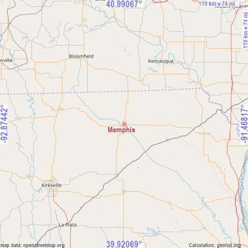
Memphis GPS coordinates[2]
40° 27' 28.116" North, 92° 10' 16.644" West
| Map corner | latitude | longitude |
|---|---|---|
| Upper-left | 40.99067°, | -92.87442° |
| Center: | 40.45781°, | -92.17129° |
| Lower-right: | 39.92069°, | -91.46817° |
| Map W x H: | 119×119 km | = 73.9×73.9mi |
| max Lat: | 71.29058° ⇑41.5% North |
| Memphis: | 40.45781° |
| min Lat: | ⇓58.5% South 19.06759° |
| min Long | Memphis | max Long |
| -171.73463° | -92.17129° | -66.98998° |
| W 35.5%⇐ | ⇒64.5% E |
Elevation
Elevation of Memphis is 244 m = 801 ft, and this is 50.8 m = 167 ft below average elevation for this country.
| Max E: |
3189 m = 10463 ft | 39% |
| Avg. | 294.8 m = 967 ft | |
| Memphis | 244 m = 801 ft | |
Min E: |
-60 m = -197 ft | 61% |
See also: United States elevation on elevation.city.
Geographical zone
Memphis is located in North temperate zone (between Tropic of Cancer and the Arctic Circle). Distance of this Northern Tropic circle is 1892.6 km =1176 mi to South.| Distance of | km | miles | from Memphis |
|---|---|---|---|
| North Pole | 5508.6 | 3422.9 | to North |
| Arctic Circle | 2902.7 | 1803.7 | to North |
| Tropic Cancer | 1892.6 | 1176 | to South |
| Equator | 4498.5 | 2795.2 | to South |


Nearby cities:
15 places around Memphis: (largest is in red/bold)
• Bloomfield
38.6 km =24 mi,  327°
327°
• Donnellson
55.2 km =34.3 mi,  68°
68°
• Edina
32.3 km =20.1 mi,  180°
180°
• Eldon
51.4 km =31.9 mi,  355°
355°
• Farmington
41.5 km =25.8 mi,  60°
60°
• Kahoka
38.5 km =23.9 mi,  96°
96°
• Keosauqua
35.1 km =21.8 mi,  30°
30°
• Kirksville
45.6 km =28.3 mi,  230°
230°
• La Belle
43.8 km =27.2 mi,  149°
149°
• Lancaster
31 km =19.3 mi,  283°
283°
• Lewistown
51.3 km =31.9 mi,  143°
143°
• Monticello
54.2 km =33.7 mi,  134°
134°
• Moulton
49.7 km =30.9 mi,  300°
300°
• Queen City
34 km =21.1 mi,  260°
260°
• Wayland
50.3 km =31.3 mi, 98°
Sources, notices
• [Note1] Compared only with cities in United States existing in our database
• [Src1] Map data: © OpenStreetMap contributors (CC-BY-SA)
• [Src2] Other city data from geonames.org with taken over terms of usage.
• [Src3] Geographical zone / Annual Mean Temperature by Robert A. Rohde @ Wikipedia
