Kahoka geodata
Kahoka (Missouri) is a seat of a second-order administrative division; located in United States in America/Chicago (GMT-5) time zone. With population of 2,024 people, there are 11881 cities with bigger population in this country. Compared to other cities in United States, 58.1% of cities are located further ↓South; 63.5% of cities are located further →East and 54.4% of cities have lower elevation than Kahoka. Note1


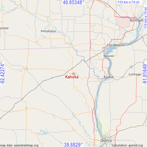
Kahoka GPS coordinates[2]
40° 25' 13.152" North, 91° 43' 10.596" West
| Map corner | latitude | longitude |
|---|---|---|
| Upper-left | 40.95348°, | -92.42274° |
| Center: | 40.42032°, | -91.71961° |
| Lower-right: | 39.8829°, | -91.01649° |
| Map W x H: | 119×119 km | = 73.9×73.9mi |
| max Lat: | 71.29058° ⇑41.9% North |
| Kahoka: | 40.42032° |
| min Lat: | ⇓58.1% South 19.06759° |
| min Long | Kahoka | max Long |
| -171.73463° | -91.71961° | -66.98998° |
| W 36.5%⇐ | ⇒63.5% E |
Elevation
Elevation of Kahoka is 216 m = 709 ft, and this is 78.8 m = 259 ft below average elevation for this country.
| Max E: |
3189 m = 10463 ft | 45.6% |
| Avg. | 294.8 m = 967 ft | |
| Kahoka | 216 m = 709 ft | |
Min E: |
-60 m = -197 ft | 54.4% |
See also: United States elevation on elevation.city.
Geographical zone
Kahoka is located in North temperate zone (between Tropic of Cancer and the Arctic Circle). Distance of this Northern Tropic circle is 1888.4 km =1173.4 mi to South.| Distance of | km | miles | from Kahoka |
|---|---|---|---|
| North Pole | 5512.7 | 3425.4 | to North |
| Arctic Circle | 2906.9 | 1806.3 | to North |
| Tropic Cancer | 1888.4 | 1173.4 | to South |
| Equator | 4494.3 | 2792.6 | to South |


Nearby cities:
15 places around Kahoka: (largest is in red/bold)
• Canton
33.8 km =21 mi,  166°
166°
• Donnellson
28 km =17.4 mi,  27°
27°
• Farmington
24.5 km =15.2 mi,  355°
355°
• Hamilton
32.3 km =20.1 mi,  94°
94°
• Keokuk
28.5 km =17.7 mi,  95°
95°
• Keosauqua
40.1 km =24.9 mi,  329°
329°
• La Belle
37.5 km =23.3 mi,  205°
205°
• Lewistown
38 km =23.6 mi,  192°
192°
• Memphis
38.5 km =23.9 mi,  276°
276°
• Monticello
33.6 km =20.9 mi,  178°
178°
• Montrose
28.6 km =17.8 mi,  64°
64°
• Nauvoo
31.8 km =19.8 mi, 63°
• Warsaw
25.1 km =15.6 mi,  105°
105°
• Wayland
11.9 km =7.4 mi, 103°
• West Point
40 km =24.9 mi, 34°
Sources, notices
• [Note1] Compared only with cities in United States existing in our database
• [Src1] Map data: © OpenStreetMap contributors (CC-BY-SA)
• [Src2] Other city data from geonames.org with taken over terms of usage.
• [Src3] Geographical zone / Annual Mean Temperature by Robert A. Rohde @ Wikipedia
