Montezuma geodata
Montezuma (Iowa) is a seat of a second-order administrative division; located in United States in America/Chicago (GMT-5) time zone. With population of 1,411 people, there are 14059 cities with bigger population in this country. Compared to other cities in United States, 71.7% of cities are located further ↓South; 65.3% of cities are located further →East and 70.9% of cities have lower elevation than Montezuma. Note1


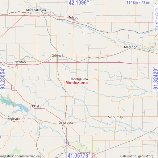
Montezuma GPS coordinates[2]
41° 35' 8.988" North, 92° 31' 38.676" West
| Map corner | latitude | longitude |
|---|---|---|
| Upper-left | 42.1096°, | -93.23054° |
| Center: | 41.58583°, | -92.52741° |
| Lower-right: | 41.05778°, | -91.82429° |
| Map W x H: | 117×117 km | = 72.7×72.7mi |
| max Lat: | 71.29058° ⇑28.3% North |
| Montezuma: | 41.58583° |
| min Lat: | ⇓71.7% South 19.06759° |
| min Long | Montezuma | max Long |
| -171.73463° | -92.52741° | -66.98998° |
| W 34.7%⇐ | ⇒65.3% E |
Elevation
Elevation of Montezuma is 290 m = 951 ft, and this is 4.8 m = 16 ft below average elevation for this country.
| Max E: |
3189 m = 10463 ft | 29.1% |
| Avg. | 294.8 m = 967 ft | |
| Montezuma | 290 m = 951 ft | |
Min E: |
-60 m = -197 ft | 70.9% |
See also: United States elevation on elevation.city.
Geographical zone
Montezuma is located in North temperate zone (between Tropic of Cancer and the Arctic Circle). Distance of this Northern Tropic circle is 2018 km =1253.9 mi to South.| Distance of | km | miles | from Montezuma |
|---|---|---|---|
| North Pole | 5383.2 | 3345 | to North |
| Arctic Circle | 2777.3 | 1725.7 | to North |
| Tropic Cancer | 2018 | 1253.9 | to South |
| Equator | 4623.9 | 2873.2 | to South |


Nearby cities:
15 places around Montezuma: (largest is in red/bold)
• Belle Plaine
40.3 km =25 mi,  30°
30°
• Brooklyn
17.8 km =11.1 mi,  22°
22°
• Fremont
42.2 km =26.2 mi,  169°
169°
• Gilman
39.2 km =24.4 mi,  326°
326°
• Grinnell
23.8 km =14.8 mi,  317°
317°
• Kellogg
34.8 km =21.6 mi,  294°
294°
• New Sharon
16.5 km =10.3 mi,  218°
218°
• North English
38.4 km =23.9 mi,  102°
102°
• Oskaloosa
33.6 km =20.9 mi,  196°
196°
• Pella
37.9 km =23.5 mi,  238°
238°
• Sigourney
38.9 km =24.2 mi,  136°
136°
• Sully
26.4 km =16.4 mi,  268°
268°
• Tama
42.5 km =26.4 mi,  354°
354°
• Victor
25 km =15.5 mi,  49°
49°
• What Cheer
25.1 km =15.6 mi, 144°
Sources, notices
• [Note1] Compared only with cities in United States existing in our database
• [Src1] Map data: © OpenStreetMap contributors (CC-BY-SA)
• [Src2] Other city data from geonames.org with taken over terms of usage.
• [Src3] Geographical zone / Annual Mean Temperature by Robert A. Rohde @ Wikipedia
