Sully geodata
Sully (Iowa) is a populated place; located in United States in America/Chicago (GMT-5) time zone. With population of 822 people, there are 17600 cities with bigger population in this country. Compared to other cities in United States, 71.6% of cities are located further ↓South; 65.9% of cities are located further →East and 69% of cities have lower elevation than Sully. Note1


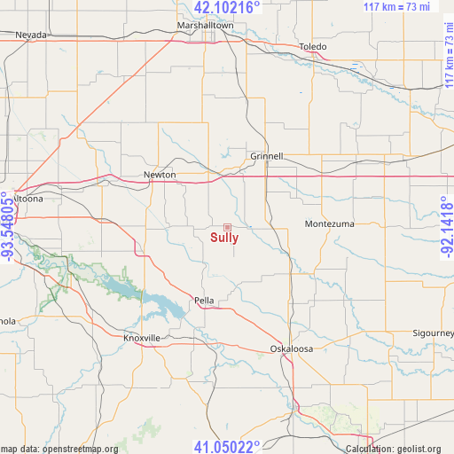
Sully GPS coordinates[2]
41° 34' 41.988" North, 92° 50' 41.712" West
| Map corner | latitude | longitude |
|---|---|---|
| Upper-left | 42.10216°, | -93.54805° |
| Center: | 41.57833°, | -92.84492° |
| Lower-right: | 41.05022°, | -92.1418° |
| Map W x H: | 117×117 km | = 72.7×72.7mi |
| max Lat: | 71.29058° ⇑28.4% North |
| Sully: | 41.57833° |
| min Lat: | ⇓71.6% South 19.06759° |
| min Long | Sully | max Long |
| -171.73463° | -92.84492° | -66.98998° |
| W 34.1%⇐ | ⇒65.9% E |
Elevation
Elevation of Sully is 281 m = 922 ft, and this is 13.8 m = 45 ft below average elevation for this country.
| Max E: |
3189 m = 10463 ft | 31% |
| Avg. | 294.8 m = 967 ft | |
| Sully | 281 m = 922 ft | |
Min E: |
-60 m = -197 ft | 69% |
See also: United States elevation on elevation.city.
Geographical zone
Sully is located in North temperate zone (between Tropic of Cancer and the Arctic Circle). Distance of this Northern Tropic circle is 2017.2 km =1253.4 mi to South.| Distance of | km | miles | from Sully |
|---|---|---|---|
| North Pole | 5384 | 3345.5 | to North |
| Arctic Circle | 2778.1 | 1726.2 | to North |
| Tropic Cancer | 2017.2 | 1253.4 | to South |
| Equator | 4623.1 | 2872.7 | to South |


Nearby cities:
15 places around Sully: (largest is in red/bold)
• Baxter
37.5 km =23.3 mi,  317°
317°
• Brooklyn
37.4 km =23.2 mi,  62°
62°
• Colfax
35.1 km =21.8 mi,  288°
288°
• Gilman
33.7 km =20.9 mi,  7°
7°
• Grinnell
21 km =13 mi,  29°
29°
• Kellogg
16.4 km =10.2 mi,  341°
341°
• Knoxville
36.1 km =22.4 mi,  217°
217°
• Monroe
22.3 km =13.9 mi,  253°
253°
• Montezuma
26.4 km =16.4 mi,  88°
88°
• New Sharon
20.1 km =12.5 mi,  126°
126°
• Newton
21.6 km =13.4 mi,  308°
308°
• Oskaloosa
35.5 km =22.1 mi,  151°
151°
• Pella
19.8 km =12.3 mi,  197°
197°
• Pleasantville
41.3 km =25.7 mi,  238°
238°
• Prairie City
32.5 km =20.2 mi,  274°
274°
Sources, notices
• [Note1] Compared only with cities in United States existing in our database
• [Src1] Map data: © OpenStreetMap contributors (CC-BY-SA)
• [Src2] Other city data from geonames.org with taken over terms of usage.
• [Src3] Geographical zone / Annual Mean Temperature by Robert A. Rohde @ Wikipedia
