Shenandoah geodata
Shenandoah (Iowa) is a populated place; located in United States in America/Chicago (GMT-5) time zone. With population of 5,021 people, there are 7152 cities with bigger population in this country. Compared to other cities in United States, 62.6% of cities are located further ↓South; 72% of cities are located further →East and 72.2% of cities have lower elevation than Shenandoah. Note1


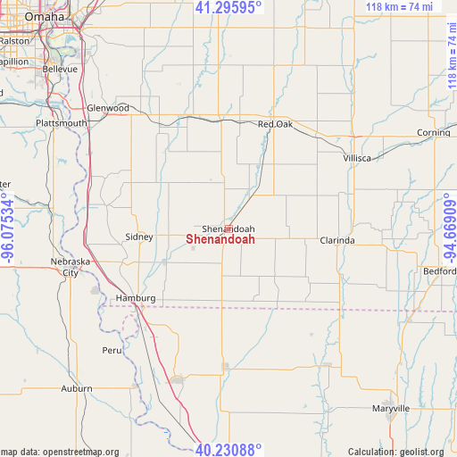
Shenandoah GPS coordinates[2]
40° 45' 55.98" North, 95° 22' 19.956" West
| Map corner | latitude | longitude |
|---|---|---|
| Upper-left | 41.29595°, | -96.07534° |
| Center: | 40.76555°, | -95.37221° |
| Lower-right: | 40.23088°, | -94.66909° |
| Map W x H: | 118.4×118.4 km | = 73.6×73.6mi |
| max Lat: | 71.29058° ⇑37.4% North |
| Shenandoah: | 40.76555° |
| min Lat: | ⇓62.6% South 19.06759° |
| min Long | Shenandoah | max Long |
| -171.73463° | -95.37221° | -66.98998° |
| W 28%⇐ | ⇒72% E |
Elevation
Elevation of Shenandoah is 297 m = 974 ft, and this is 2.2 m = 7 ft above average elevation for this country.
| Max E: |
3189 m = 10463 ft | 27.8% |
| Shenandoah | 297 m 974 ft | |
| Avg. | 294.8 m = 967 ft | |
Min E: |
-60 m = -197 ft | 72.2% |
See also: United States elevation on elevation.city.
Geographical zone
Shenandoah is located in North temperate zone (between Tropic of Cancer and the Arctic Circle). Distance of this Northern Tropic circle is 1926.8 km =1197.3 mi to South.| Distance of | km | miles | from Shenandoah |
|---|---|---|---|
| North Pole | 5474.4 | 3401.6 | to North |
| Arctic Circle | 2868.5 | 1782.4 | to North |
| Tropic Cancer | 1926.8 | 1197.3 | to South |
| Equator | 4532.7 | 2816.5 | to South |


Nearby cities:
15 places around Shenandoah: (largest is in red/bold)
• Burlington Junction
44 km =27.3 mi,  144°
144°
• Clarinda
28.3 km =17.6 mi,  95°
95°
• Essex
9.3 km =5.8 mi,  35°
35°
• Glenwood
44.1 km =27.4 mi,  315°
315°
• Hamburg
30 km =18.6 mi,  233°
233°
• Malvern
31.9 km =19.8 mi,  325°
325°
• Nebraska City
42.2 km =26.2 mi,  256°
256°
• Peru
44.5 km =27.7 mi,  223°
223°
• Red Oak
29.8 km =18.5 mi,  24°
24°
• Rock Port
41.3 km =25.7 mi,  197°
197°
• Sidney
23.3 km =14.5 mi,  265°
265°
• Stanton
32.9 km =20.4 mi, 43°
• Tabor
29.2 km =18.1 mi,  300°
300°
• Tarkio
36.2 km =22.5 mi,  180°
180°
• Villisca
38 km =23.6 mi,  61°
61°
Sources, notices
• [Note1] Compared only with cities in United States existing in our database
• [Src1] Map data: © OpenStreetMap contributors (CC-BY-SA)
• [Src2] Other city data from geonames.org with taken over terms of usage.
• [Src3] Geographical zone / Annual Mean Temperature by Robert A. Rohde @ Wikipedia
