Tabor geodata
Tabor (Iowa) is a populated place; located in United States in America/Chicago (GMT-5) time zone. With population of 979 people, there are 16420 cities with bigger population in this country. Compared to other cities in United States, 64.7% of cities are located further ↓South; 72.7% of cities are located further →East and 82.6% of cities have lower elevation than Tabor. Note1


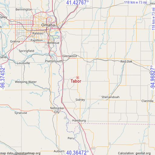
Tabor GPS coordinates[2]
40° 53' 53.988" North, 95° 40' 17.004" West
| Map corner | latitude | longitude |
|---|---|---|
| Upper-left | 41.42767°, | -96.37452° |
| Center: | 40.89833°, | -95.67139° |
| Lower-right: | 40.36472°, | -94.96827° |
| Map W x H: | 118.2×118.2 km | = 73.4×73.4mi |
| max Lat: | 71.29058° ⇑35.3% North |
| Tabor: | 40.89833° |
| min Lat: | ⇓64.7% South 19.06759° |
| min Long | Tabor | max Long |
| -171.73463° | -95.67139° | -66.98998° |
| W 27.3%⇐ | ⇒72.7% E |
Elevation
Elevation of Tabor is 383 m = 1257 ft, and this is 88.2 m = 289 ft above average elevation for this country.
| Max E: |
3189 m = 10463 ft | 17.4% |
| Tabor | 383 m 1257 ft | |
| Avg. | 294.8 m = 967 ft | |
Min E: |
-60 m = -197 ft | 82.6% |
See also: United States elevation on elevation.city.
Geographical zone
Tabor is located in North temperate zone (between Tropic of Cancer and the Arctic Circle). Distance of this Northern Tropic circle is 1941.5 km =1206.4 mi to South.| Distance of | km | miles | from Tabor |
|---|---|---|---|
| North Pole | 5459.6 | 3392.4 | to North |
| Arctic Circle | 2853.7 | 1773.2 | to North |
| Tropic Cancer | 1941.5 | 1206.4 | to South |
| Equator | 4547.5 | 2825.7 | to South |


Nearby cities:
15 places around Tabor: (largest is in red/bold)
• Bellevue
32.3 km =20.1 mi,  325°
325°
• Essex
31.4 km =19.5 mi,  103°
103°
• Glenwood
17.6 km =10.9 mi,  340°
340°
• Hamburg
32.7 km =20.3 mi,  177°
177°
• Louisville
42.7 km =26.5 mi,  285°
285°
• Malvern
13.7 km =8.5 mi,  31°
31°
• Nebraska City
29.3 km =18.2 mi,  212°
212°
• Offutt Air Force Base
32.4 km =20.1 mi,  319°
319°
• Papillion
42.2 km =26.2 mi,  312°
312°
• Plattsmouth
21.7 km =13.5 mi, 305°
• Red Oak
39.4 km =24.5 mi,  71°
71°
• Shenandoah
29.2 km =18.1 mi,  120°
120°
• Sidney
16.8 km =10.4 mi,  173°
173°
• Treynor
37.5 km =23.3 mi,  7°
7°
• Weeping Water
39.6 km =24.6 mi,  265°
265°
Sources, notices
• [Note1] Compared only with cities in United States existing in our database
• [Src1] Map data: © OpenStreetMap contributors (CC-BY-SA)
• [Src2] Other city data from geonames.org with taken over terms of usage.
• [Src3] Geographical zone / Annual Mean Temperature by Robert A. Rohde @ Wikipedia
