Glenwood geodata
Glenwood (Iowa) is a seat of a second-order administrative division; located in United States in America/Chicago (GMT-5) time zone. With population of 5,253 people, there are 6950 cities with bigger population in this country. Compared to other cities in United States, 66.4% of cities are located further ↓South; 72.9% of cities are located further →East and 74.2% of cities have lower elevation than Glenwood. Note1


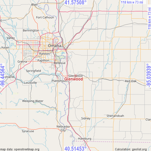
Glenwood GPS coordinates[2]
41° 2' 48.984" North, 95° 44' 33.036" West
| Map corner | latitude | longitude |
|---|---|---|
| Upper-left | 41.57508°, | -96.44564° |
| Center: | 41.04694°, | -95.74251° |
| Lower-right: | 40.51453°, | -95.03939° |
| Map W x H: | 117.9×117.9 km | = 73.3×73.3mi |
| max Lat: | 71.29058° ⇑33.6% North |
| Glenwood: | 41.04694° |
| min Lat: | ⇓66.4% South 19.06759° |
| min Long | Glenwood | max Long |
| -171.73463° | -95.74251° | -66.98998° |
| W 27.1%⇐ | ⇒72.9% E |
Elevation
Elevation of Glenwood is 308 m = 1010 ft, and this is 13.2 m = 43 ft above average elevation for this country.
| Max E: |
3189 m = 10463 ft | 25.8% |
| Glenwood | 308 m 1010 ft | |
| Avg. | 294.8 m = 967 ft | |
Min E: |
-60 m = -197 ft | 74.2% |
See also: United States elevation on elevation.city.
Geographical zone
Glenwood is located in North temperate zone (between Tropic of Cancer and the Arctic Circle). Distance of this Northern Tropic circle is 1958.1 km =1216.7 mi to South.| Distance of | km | miles | from Glenwood |
|---|---|---|---|
| North Pole | 5443.1 | 3382.2 | to North |
| Arctic Circle | 2837.2 | 1763 | to North |
| Tropic Cancer | 1958.1 | 1216.7 | to South |
| Equator | 4564 | 2835.9 | to South |


Nearby cities:
15 places around Glenwood: (largest is in red/bold)
• Bellevue
15.9 km =9.9 mi,  308°
308°
• Carson
34.4 km =21.4 mi,  52°
52°
• Carter Lake
30.8 km =19.1 mi,  331°
331°
• Council Bluffs
25.9 km =16.1 mi,  337°
337°
• La Vista
28.6 km =17.8 mi,  302°
302°
• Malvern
14.1 km =8.8 mi,  110°
110°
• Offutt Air Force Base
17 km =10.6 mi, 298°
• Omaha
28.6 km =17.8 mi,  324°
324°
• Papillion
27.8 km =17.3 mi, 295°
• Plattsmouth
12.4 km =7.7 mi,  251°
251°
• Ralston
30.7 km =19.1 mi, 305°
• Sidney
34.1 km =21.2 mi,  166°
166°
• Springfield
33.1 km =20.6 mi,  276°
276°
• Tabor
17.6 km =10.9 mi,  160°
160°
• Treynor
23.3 km =14.5 mi,  27°
27°
Sources, notices
• [Note1] Compared only with cities in United States existing in our database
• [Src1] Map data: © OpenStreetMap contributors (CC-BY-SA)
• [Src2] Other city data from geonames.org with taken over terms of usage.
• [Src3] Geographical zone / Annual Mean Temperature by Robert A. Rohde @ Wikipedia
