Stanton geodata
Stanton (Iowa) is a populated place; located in United States in America/Chicago (GMT-5) time zone. With population of 639 people, there are 19276 cities with bigger population in this country. Compared to other cities in United States, 65.6% of cities are located further ↓South; 71.4% of cities are located further →East and 80% of cities have lower elevation than Stanton. Note1


Stanton GPS coordinates[2]
40° 58' 53.976" North, 95° 6' 14.94" West
| Map corner | latitude | longitude |
|---|---|---|
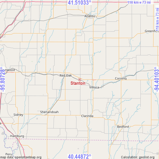
| Upper-left | 41.51033°, | -95.80728° |
| Center: | 40.98166°, | -95.10415° |
| Lower-right: | 40.44872°, | -94.40103° |
| Map W x H: | 118×118 km | = 73.3×73.3mi |
| max Lat: | 71.29058° ⇑34.4% North |
| Stanton: | 40.98166° |
| min Lat: | ⇓65.6% South 19.06759° |
| min Long | Stanton | max Long |
| -171.73463° | -95.10415° | -66.98998° |
| W 28.6%⇐ | ⇒71.4% E |
Elevation
Elevation of Stanton is 353 m = 1158 ft, and this is 58.2 m = 191 ft above average elevation for this country.
| Max E: |
3189 m = 10463 ft | 20% |
| Stanton | 353 m 1158 ft | |
| Avg. | 294.8 m = 967 ft | |
Min E: |
-60 m = -197 ft | 80% |
See also: United States elevation on elevation.city.
Geographical zone
Stanton is located in North temperate zone (between Tropic of Cancer and the Arctic Circle). Distance of this Northern Tropic circle is 1950.8 km =1212.2 mi to South.| Distance of | km | miles | from Stanton |
|---|---|---|---|
| North Pole | 5450.3 | 3386.7 | to North |
| Arctic Circle | 2844.4 | 1767.4 | to North |
| Tropic Cancer | 1950.8 | 1212.2 | to South |
| Equator | 4556.7 | 2831.4 | to South |


Nearby cities:
15 places around Stanton: (largest is in red/bold)
• Atlantic
47.5 km =29.5 mi,  9°
9°
• Bedford
47.6 km =29.6 mi,  137°
137°
• Carson
38.7 km =24 mi,  317°
317°
• Clarinda
27.5 km =17.1 mi,  168°
168°
• Corning
30.5 km =19 mi,  88°
88°
• Essex
23.8 km =14.8 mi,  226°
226°
• Griswold
28.3 km =17.6 mi,  354°
354°
• Lenox
46.9 km =29.1 mi,  103°
103°
• Malvern
40.4 km =25.1 mi,  273°
273°
• Oakland
43.9 km =27.3 mi,  326°
326°
• Red Oak
10.7 km =6.6 mi,  287°
287°
• Shenandoah
32.9 km =20.4 mi,  223°
223°
• Tabor
48.5 km =30.1 mi,  258°
258°
• Treynor
50.9 km =31.6 mi,  303°
303°
• Villisca
12.2 km =7.6 mi,  118°
118°
Sources, notices
• [Note1] Compared only with cities in United States existing in our database
• [Src1] Map data: © OpenStreetMap contributors (CC-BY-SA)
• [Src2] Other city data from geonames.org with taken over terms of usage.
• [Src3] Geographical zone / Annual Mean Temperature by Robert A. Rohde @ Wikipedia
