Malvern geodata
Malvern (Iowa) is a populated place; located in United States in America/Chicago (GMT-5) time zone. With population of 1,117 people, there are 15584 cities with bigger population in this country. Compared to other cities in United States, 65.9% of cities are located further ↓South; 72.5% of cities are located further →East and 73.8% of cities have lower elevation than Malvern. Note1


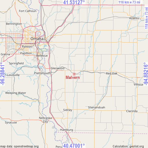
Malvern GPS coordinates[2]
41° 0' 10.008" North, 95° 35' 7.008" West
| Map corner | latitude | longitude |
|---|---|---|
| Upper-left | 41.53127°, | -96.28841° |
| Center: | 41.00278°, | -95.58528° |
| Lower-right: | 40.47001°, | -94.88216° |
| Map W x H: | 118×118 km | = 73.3×73.3mi |
| max Lat: | 71.29058° ⇑34.1% North |
| Malvern: | 41.00278° |
| min Lat: | ⇓65.9% South 19.06759° |
| min Long | Malvern | max Long |
| -171.73463° | -95.58528° | -66.98998° |
| W 27.5%⇐ | ⇒72.5% E |
Elevation
Elevation of Malvern is 306 m = 1004 ft, and this is 11.2 m = 37 ft above average elevation for this country.
| Max E: |
3189 m = 10463 ft | 26.2% |
| Malvern | 306 m 1004 ft | |
| Avg. | 294.8 m = 967 ft | |
Min E: |
-60 m = -197 ft | 73.8% |
See also: United States elevation on elevation.city.
Geographical zone
Malvern is located in North temperate zone (between Tropic of Cancer and the Arctic Circle). Distance of this Northern Tropic circle is 1953.2 km =1213.7 mi to South.| Distance of | km | miles | from Malvern |
|---|---|---|---|
| North Pole | 5448 | 3385.2 | to North |
| Arctic Circle | 2842.1 | 1766 | to North |
| Tropic Cancer | 1953.2 | 1213.7 | to South |
| Equator | 4559.1 | 2832.9 | to South |


Nearby cities:
15 places around Malvern: (largest is in red/bold)
• Bellevue
29.6 km =18.4 mi,  300°
300°
• Carson
29.5 km =18.3 mi,  28°
28°
• Council Bluffs
36.9 km =22.9 mi,  321°
321°
• Essex
29.9 km =18.6 mi,  128°
128°
• Glenwood
14.1 km =8.8 mi,  290°
290°
• Oakland
37.5 km =23.3 mi,  24°
24°
• Offutt Air Force Base
31 km =19.3 mi, 294°
• Omaha
41 km =25.5 mi,  313°
313°
• Plattsmouth
24.9 km =15.5 mi,  272°
272°
• Red Oak
30.2 km =18.8 mi,  88°
88°
• Shenandoah
31.9 km =19.8 mi,  145°
145°
• Sidney
28.8 km =17.9 mi,  190°
190°
• Stanton
40.4 km =25.1 mi, 93°
• Tabor
13.7 km =8.5 mi,  211°
211°
• Treynor
25.6 km =15.9 mi,  354°
354°
Sources, notices
• [Note1] Compared only with cities in United States existing in our database
• [Src1] Map data: © OpenStreetMap contributors (CC-BY-SA)
• [Src2] Other city data from geonames.org with taken over terms of usage.
• [Src3] Geographical zone / Annual Mean Temperature by Robert A. Rohde @ Wikipedia
