Clayton geodata
Clayton (Illinois) is a populated place; located in United States in America/Chicago (GMT-5) time zone. With population of 745 people, there are 18255 cities with bigger population in this country. Compared to other cities in United States, 53.9% of cities are located further ↓South; 62% of cities are located further →East and 56.7% of cities have lower elevation than Clayton. Note1


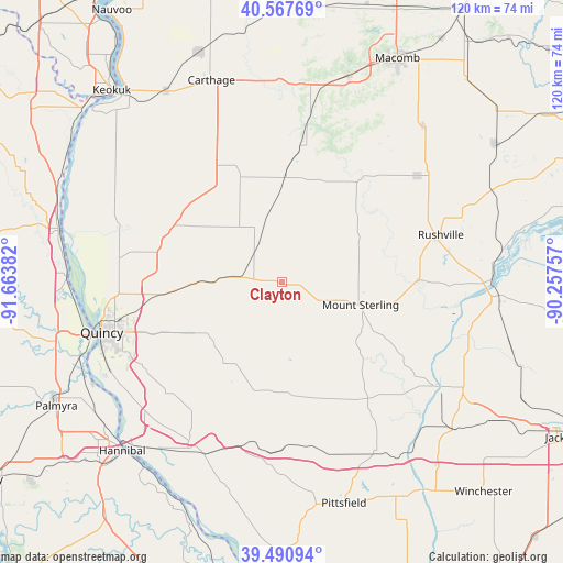
Clayton GPS coordinates[2]
40° 1' 53.184" North, 90° 57' 38.484" West
| Map corner | latitude | longitude |
|---|---|---|
| Upper-left | 40.56769°, | -91.66382° |
| Center: | 40.03144°, | -90.96069° |
| Lower-right: | 39.49094°, | -90.25757° |
| Map W x H: | 119.7×119.7 km | = 74.4×74.4mi |
| max Lat: | 71.29058° ⇑46.1% North |
| Clayton: | 40.03144° |
| min Lat: | ⇓53.9% South 19.06759° |
| min Long | Clayton | max Long |
| -171.73463° | -90.96069° | -66.98998° |
| W 38%⇐ | ⇒62% E |
Elevation
Elevation of Clayton is 225 m = 738 ft, and this is 69.8 m = 229 ft below average elevation for this country.
| Max E: |
3189 m = 10463 ft | 43.3% |
| Avg. | 294.8 m = 967 ft | |
| Clayton | 225 m = 738 ft | |
Min E: |
-60 m = -197 ft | 56.7% |
See also: United States elevation on elevation.city.
Geographical zone
Clayton is located in North temperate zone (between Tropic of Cancer and the Arctic Circle). Distance of this Northern Tropic circle is 1845.2 km =1146.6 mi to South.| Distance of | km | miles | from Clayton |
|---|---|---|---|
| North Pole | 5556 | 3452.3 | to North |
| Arctic Circle | 2950.1 | 1833.1 | to North |
| Tropic Cancer | 1845.2 | 1146.6 | to South |
| Equator | 4451.1 | 2765.8 | to South |


Nearby cities:
15 places around Clayton: (largest is in red/bold)
• Augusta
22.1 km =13.7 mi,  2°
2°
• Barry
38.1 km =23.7 mi,  190°
190°
• Beardstown
45.7 km =28.4 mi,  91°
91°
• Camp Point
9.3 km =5.8 mi,  275°
275°
• Carthage
45.3 km =28.1 mi,  340°
340°
• Golden
9.9 km =6.2 mi,  330°
330°
• Griggsville
41.1 km =25.5 mi,  150°
150°
• Liberty
21 km =13 mi,  216°
216°
• Mendon
28.2 km =17.5 mi, 282°
• Meredosia
40.8 km =25.4 mi,  123°
123°
• Mount Sterling
17.5 km =10.9 mi,  106°
106°
• Payson
33.8 km =21 mi,  225°
225°
• Quincy
39.7 km =24.7 mi,  254°
254°
• Rushville
35.3 km =21.9 mi,  73°
73°
• Ursa
34.9 km =21.7 mi, 277°
Sources, notices
• [Note1] Compared only with cities in United States existing in our database
• [Src1] Map data: © OpenStreetMap contributors (CC-BY-SA)
• [Src2] Other city data from geonames.org with taken over terms of usage.
• [Src3] Geographical zone / Annual Mean Temperature by Robert A. Rohde @ Wikipedia
