Liberty geodata
Liberty (Illinois) is a populated place; located in United States in America/Chicago (GMT-5) time zone. With population of 513 people, there are 20718 cities with bigger population in this country. Compared to other cities in United States, 52.2% of cities are located further ↓South; 62.3% of cities are located further →East and 58.6% of cities have lower elevation than Liberty. Note1


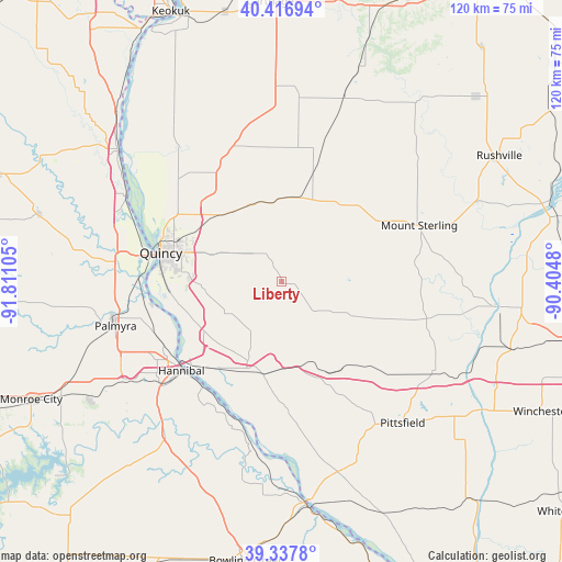
Liberty GPS coordinates[2]
39° 52' 46.164" North, 91° 6' 28.512" West
| Map corner | latitude | longitude |
|---|---|---|
| Upper-left | 40.41694°, | -91.81105° |
| Center: | 39.87949°, | -91.10792° |
| Lower-right: | 39.3378°, | -90.4048° |
| Map W x H: | 120×120 km | = 74.6×74.6mi |
| max Lat: | 71.29058° ⇑47.8% North |
| Liberty: | 39.87949° |
| min Lat: | ⇓52.2% South 19.06759° |
| min Long | Liberty | max Long |
| -171.73463° | -91.10792° | -66.98998° |
| W 37.7%⇐ | ⇒62.3% E |
Elevation
Elevation of Liberty is 233 m = 764 ft, and this is 61.8 m = 203 ft below average elevation for this country.
| Max E: |
3189 m = 10463 ft | 41.4% |
| Avg. | 294.8 m = 967 ft | |
| Liberty | 233 m = 764 ft | |
Min E: |
-60 m = -197 ft | 58.6% |
See also: United States elevation on elevation.city.
Geographical zone
Liberty is located in North temperate zone (between Tropic of Cancer and the Arctic Circle). Distance of this Northern Tropic circle is 1828.3 km =1136.1 mi to South.| Distance of | km | miles | from Liberty |
|---|---|---|---|
| North Pole | 5572.9 | 3462.8 | to North |
| Arctic Circle | 2967 | 1843.6 | to North |
| Tropic Cancer | 1828.3 | 1136.1 | to South |
| Equator | 4434.2 | 2755.3 | to South |


Nearby cities:
15 places around Liberty: (largest is in red/bold)
• Augusta
41.2 km =25.6 mi,  19°
19°
• Barry
21.4 km =13.3 mi,  164°
164°
• Camp Point
18.1 km =11.2 mi,  10°
10°
• Clayton
21 km =13 mi,  36°
36°
• Golden
26.7 km =16.6 mi, 16°
• Griggsville
37.8 km =23.5 mi,  120°
120°
• Hannibal
28.6 km =17.8 mi,  228°
228°
• La Grange
37.9 km =23.5 mi,  298°
298°
• Mendon
27.6 km =17.1 mi,  327°
327°
• Mount Sterling
31.7 km =19.7 mi,  67°
67°
• Palmyra
36.7 km =22.8 mi,  255°
255°
• Payson
13.4 km =8.3 mi,  238°
238°
• Pittsfield
39.8 km =24.7 mi,  139°
139°
• Quincy
26.5 km =16.5 mi,  283°
283°
• Ursa
31 km =19.3 mi,  314°
314°
Sources, notices
• [Note1] Compared only with cities in United States existing in our database
• [Src1] Map data: © OpenStreetMap contributors (CC-BY-SA)
• [Src2] Other city data from geonames.org with taken over terms of usage.
• [Src3] Geographical zone / Annual Mean Temperature by Robert A. Rohde @ Wikipedia
