Ursa geodata
Ursa (Illinois) is a populated place; located in United States in America/Chicago (GMT-5) time zone. With population of 623 people, there are 19434 cities with bigger population in this country. Compared to other cities in United States, 54.3% of cities are located further ↓South; 62.8% of cities are located further →East and 53.1% of cities have higher elevation than Ursa. Note1


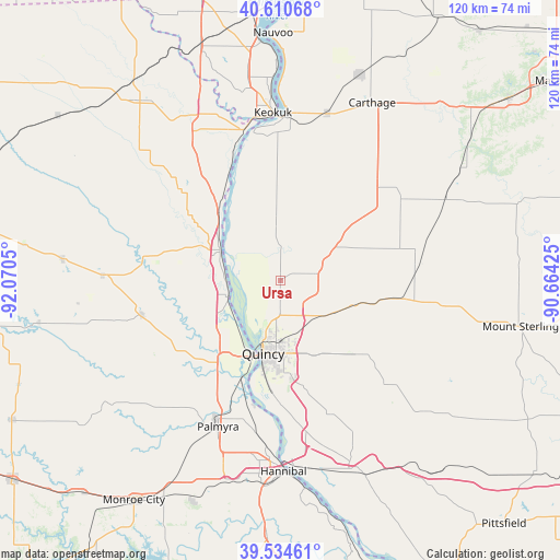
Ursa GPS coordinates[2]
40° 4' 29.172" North, 91° 22' 2.532" West
| Map corner | latitude | longitude |
|---|---|---|
| Upper-left | 40.61068°, | -92.0705° |
| Center: | 40.07477°, | -91.36737° |
| Lower-right: | 39.53461°, | -90.66425° |
| Map W x H: | 119.6×119.6 km | = 74.3×74.3mi |
| max Lat: | 71.29058° ⇑45.7% North |
| Ursa: | 40.07477° |
| min Lat: | ⇓54.3% South 19.06759° |
| min Long | Ursa | max Long |
| -171.73463° | -91.36737° | -66.98998° |
| W 37.2%⇐ | ⇒62.8% E |
Elevation
Elevation of Ursa is 187 m = 614 ft, and this is 107.8 m = 354 ft below average elevation for this country.
| Max E: |
3189 m = 10463 ft | 53.1% |
| Avg. | 294.8 m = 967 ft | |
| Ursa | 187 m = 614 ft | |
Min E: |
-60 m = -197 ft | 46.9% |
See also: United States elevation on elevation.city.
Geographical zone
Ursa is located in North temperate zone (between Tropic of Cancer and the Arctic Circle). Distance of this Northern Tropic circle is 1850 km =1149.5 mi to South.| Distance of | km | miles | from Ursa |
|---|---|---|---|
| North Pole | 5551.2 | 3449.4 | to North |
| Arctic Circle | 2945.3 | 1830.1 | to North |
| Tropic Cancer | 1850 | 1149.5 | to South |
| Equator | 4455.9 | 2768.8 | to South |


Nearby cities:
15 places around Ursa: (largest is in red/bold)
• Camp Point
25.7 km =16 mi,  98°
98°
• Canton
22.6 km =14 mi,  284°
284°
• Clayton
34.9 km =21.7 mi, 97°
• Golden
30 km =18.6 mi,  82°
82°
• Hamilton
35.8 km =22.2 mi,  3°
3°
• Keokuk
35.9 km =22.3 mi,  357°
357°
• La Grange
11.6 km =7.2 mi,  252°
252°
• Lewistown
38 km =23.6 mi,  271°
271°
• Liberty
31 km =19.3 mi,  134°
134°
• Mendon
7.3 km =4.5 mi, 77°
• Monticello
29.7 km =18.5 mi, 279°
• Palmyra
33.9 km =21.1 mi,  203°
203°
• Payson
30.6 km =19 mi,  159°
159°
• Quincy
15.9 km =9.9 mi,  193°
193°
• Warsaw
32.1 km =19.9 mi,  349°
349°
Sources, notices
• [Note1] Compared only with cities in United States existing in our database
• [Src1] Map data: © OpenStreetMap contributors (CC-BY-SA)
• [Src2] Other city data from geonames.org with taken over terms of usage.
• [Src3] Geographical zone / Annual Mean Temperature by Robert A. Rohde @ Wikipedia
