Mendon geodata
Mendon (Illinois) is a populated place; located in United States in America/Chicago (GMT-5) time zone. With population of 942 people, there are 16694 cities with bigger population in this country. Compared to other cities in United States, 54.4% of cities are located further ↓South; 62.7% of cities are located further →East and 59% of cities have lower elevation than Mendon. Note1


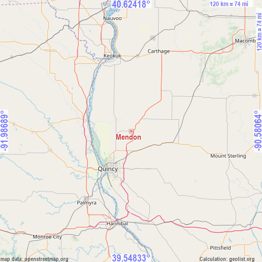
Mendon GPS coordinates[2]
40° 5' 18.168" North, 91° 17' 1.536" West
| Map corner | latitude | longitude |
|---|---|---|
| Upper-left | 40.62418°, | -91.98689° |
| Center: | 40.08838°, | -91.28376° |
| Lower-right: | 39.54833°, | -90.58064° |
| Map W x H: | 119.6×119.6 km | = 74.3×74.3mi |
| max Lat: | 71.29058° ⇑45.6% North |
| Mendon: | 40.08838° |
| min Lat: | ⇓54.4% South 19.06759° |
| min Long | Mendon | max Long |
| -171.73463° | -91.28376° | -66.98998° |
| W 37.3%⇐ | ⇒62.7% E |
Elevation
Elevation of Mendon is 235 m = 771 ft, and this is 59.8 m = 196 ft below average elevation for this country.
| Max E: |
3189 m = 10463 ft | 41% |
| Avg. | 294.8 m = 967 ft | |
| Mendon | 235 m = 771 ft | |
Min E: |
-60 m = -197 ft | 59% |
See also: United States elevation on elevation.city.
Geographical zone
Mendon is located in North temperate zone (between Tropic of Cancer and the Arctic Circle). Distance of this Northern Tropic circle is 1851.5 km =1150.5 mi to South.| Distance of | km | miles | from Mendon |
|---|---|---|---|
| North Pole | 5549.7 | 3448.4 | to North |
| Arctic Circle | 2943.8 | 1829.2 | to North |
| Tropic Cancer | 1851.5 | 1150.5 | to South |
| Equator | 4457.4 | 2769.7 | to South |


Nearby cities:
15 places around Mendon: (largest is in red/bold)
• Augusta
32.4 km =20.1 mi,  60°
60°
• Camp Point
19.1 km =11.9 mi,  106°
106°
• Canton
29.3 km =18.2 mi,  277°
277°
• Carthage
38.6 km =24 mi,  18°
18°
• Clayton
28.2 km =17.5 mi,  102°
102°
• Golden
22.8 km =14.2 mi,  84°
84°
• Hamilton
34.6 km =21.5 mi,  352°
352°
• Keokuk
35.4 km =22 mi, 345°
• La Grange
18.9 km =11.7 mi,  254°
254°
• Liberty
27.6 km =17.1 mi,  147°
147°
• Monticello
36.6 km =22.7 mi, 275°
• Payson
30.4 km =18.9 mi,  173°
173°
• Quincy
20.1 km =12.5 mi,  212°
212°
• Ursa
7.3 km =4.5 mi,  257°
257°
• Warsaw
32.7 km =20.3 mi,  336°
336°
Sources, notices
• [Note1] Compared only with cities in United States existing in our database
• [Src1] Map data: © OpenStreetMap contributors (CC-BY-SA)
• [Src2] Other city data from geonames.org with taken over terms of usage.
• [Src3] Geographical zone / Annual Mean Temperature by Robert A. Rohde @ Wikipedia
