Aurora geodata
Aurora (Illinois) is a populated place; located in United States in America/Chicago (GMT-5) time zone. With population of 200,661 people, there are 127 cities with bigger population in this country. Compared to other cities in United States, 73.5% of cities are located further ↓South; 54.2% of cities are located further →East and 53% of cities have lower elevation than Aurora. Note1


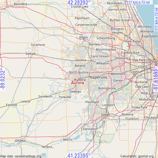
Aurora GPS coordinates[2]
41° 45' 38.088" North, 88° 19' 12.252" West
| Map corner | latitude | longitude |
|---|---|---|
| Upper-left | 42.28292°, | -89.0232° |
| Center: | 41.76058°, | -88.32007° |
| Lower-right: | 41.23395°, | -87.61695° |
| Map W x H: | 116.6×116.6 km | = 72.5×72.5mi |
| max Lat: | 71.29058° ⇑26.5% North |
| Aurora: | 41.76058° |
| min Lat: | ⇓73.5% South 19.06759° |
| min Long | Aurora | max Long |
| -171.73463° | -88.32007° | -66.98998° |
| W 45.8%⇐ | ⇒54.2% E |
Elevation
Elevation of Aurora is 210 m = 689 ft, and this is 84.8 m = 278 ft below average elevation for this country.
| Max E: |
3189 m = 10463 ft | 47% |
| Avg. | 294.8 m = 967 ft | |
| Aurora | 210 m = 689 ft | |
Min E: |
-60 m = -197 ft | 53% |
See also: Aurora elevation on elevation.city.
Geographical zone
Aurora is located in North temperate zone (between Tropic of Cancer and the Arctic Circle). Distance of this Northern Tropic circle is 2037.4 km =1266 mi to South.| Distance of | km | miles | from Aurora |
|---|---|---|---|
| North Pole | 5363.7 | 3332.8 | to North |
| Arctic Circle | 2757.8 | 1713.6 | to North |
| Tropic Cancer | 2037.4 | 1266 | to South |
| Equator | 4643.3 | 2885.2 | to South |


Nearby cities:
15 places around Aurora: (largest is in red/bold)
• Batavia
10 km =6.2 mi,  3°
3°
• Boulder Hill
5.5 km =3.4 mi,  194°
194°
• Geneva
14.2 km =8.8 mi, 4°
• Lynwood
10.5 km =6.5 mi,  215°
215°
• Montgomery
4 km =2.5 mi,  212°
212°
• Naperville
14.6 km =9.1 mi,  78°
78°
• North Aurora
5.1 km =3.2 mi,  353°
353°
• Oswego
9 km =5.6 mi,  196°
196°
• Prestbury
8.5 km =5.3 mi,  287°
287°
• Saint Charles
17.1 km =10.6 mi, 3°
• Sugar Grove
10.3 km =6.4 mi,  270°
270°
• Warrenville
13.7 km =8.5 mi,  62°
62°
• West Chicago
16.8 km =10.4 mi,  34°
34°
• Winfield
17.3 km =10.7 mi,  49°
49°
• Yorkville
17 km =10.6 mi, 218°
Sources, notices
• [Note1] Compared only with cities in United States existing in our database
• [Src1] Map data: © OpenStreetMap contributors (CC-BY-SA)
• [Src2] Other city data from geonames.org with taken over terms of usage.
• [Src3] Geographical zone / Annual Mean Temperature by Robert A. Rohde @ Wikipedia
