Oswego geodata
Oswego (Illinois) is a populated place; located in United States in America/Chicago (GMT-5) time zone. With population of 33,955 people, there are 1451 cities with bigger population in this country. Compared to other cities in United States, 72.8% of cities are located further ↓South; 54.3% of cities are located further →East and 50.5% of cities have higher elevation than Oswego. Note1


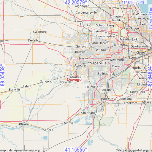
Oswego GPS coordinates[2]
41° 40' 58.116" North, 88° 21' 5.256" West
| Map corner | latitude | longitude |
|---|---|---|
| Upper-left | 42.20579°, | -89.05459° |
| Center: | 41.68281°, | -88.35146° |
| Lower-right: | 41.15555°, | -87.64834° |
| Map W x H: | 116.8×116.8 km | = 72.6×72.6mi |
| max Lat: | 71.29058° ⇑27.2% North |
| Oswego: | 41.68281° |
| min Lat: | ⇓72.8% South 19.06759° |
| min Long | Oswego | max Long |
| -171.73463° | -88.35146° | -66.98998° |
| W 45.7%⇐ | ⇒54.3% E |
Elevation
Elevation of Oswego is 196 m = 643 ft, and this is 98.8 m = 324 ft below average elevation for this country.
| Max E: |
3189 m = 10463 ft | 50.5% |
| Avg. | 294.8 m = 967 ft | |
| Oswego | 196 m = 643 ft | |
Min E: |
-60 m = -197 ft | 49.5% |
See also: United States elevation on elevation.city.
Geographical zone
Oswego is located in North temperate zone (between Tropic of Cancer and the Arctic Circle). Distance of this Northern Tropic circle is 2028.8 km =1260.6 mi to South.| Distance of | km | miles | from Oswego |
|---|---|---|---|
| North Pole | 5372.4 | 3338.3 | to North |
| Arctic Circle | 2766.5 | 1719 | to North |
| Tropic Cancer | 2028.8 | 1260.6 | to South |
| Equator | 4634.7 | 2879.9 | to South |


Nearby cities:
15 places around Oswego: (largest is in red/bold)
• Aurora
9 km =5.6 mi,  16°
16°
• Batavia
18.9 km =11.7 mi,  9°
9°
• Big Rock
18.6 km =11.6 mi,  299°
299°
• Boulder Hill
3.5 km =2.2 mi, 21°
• Crystal Lawns
20.4 km =12.7 mi,  127°
127°
• Lynwood
3.5 km =2.2 mi,  271°
271°
• Montgomery
5.3 km =3.3 mi,  4°
4°
• Naperville
20.5 km =12.7 mi,  55°
55°
• North Aurora
13.9 km =8.6 mi, 8°
• Plainfield
13.7 km =8.5 mi,  116°
116°
• Plano
15.6 km =9.7 mi,  261°
261°
• Prestbury
12.4 km =7.7 mi,  333°
333°
• Sugar Grove
11.6 km =7.2 mi,  318°
318°
• Warrenville
21.1 km =13.1 mi,  44°
44°
• Yorkville
9.2 km =5.7 mi,  239°
239°
Sources, notices
• [Note1] Compared only with cities in United States existing in our database
• [Src1] Map data: © OpenStreetMap contributors (CC-BY-SA)
• [Src2] Other city data from geonames.org with taken over terms of usage.
• [Src3] Geographical zone / Annual Mean Temperature by Robert A. Rohde @ Wikipedia
