Tilton geodata
Tilton (Illinois) is a populated place; located in United States in America/Chicago (GMT-5) time zone. With population of 2,626 people, there are 10338 cities with bigger population in this country. Compared to other cities in United States, 54.5% of cities are located further ↓South; 51.2% of cities are located further →East and 50.5% of cities have lower elevation than Tilton. Note1
Administrative division(s):
- Level 1: Illinois
- Level 2: Vermilion County
- Level 3: Township of Danville


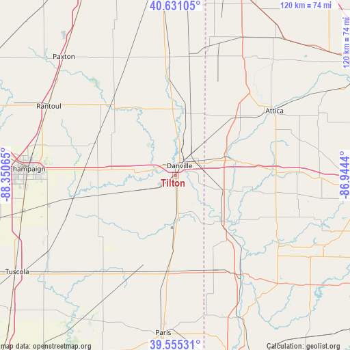
Tilton GPS coordinates[2]
40° 5' 43.116" North, 87° 38' 51.072" West
| Map corner | latitude | longitude |
|---|---|---|
| Upper-left | 40.63105°, | -88.35065° |
| Center: | 40.09531°, | -87.64752° |
| Lower-right: | 39.55531°, | -86.9444° |
| Map W x H: | 119.6×119.6 km | = 74.3×74.3mi |
| max Lat: | 71.29058° ⇑45.5% North |
| Tilton: | 40.09531° |
| min Lat: | ⇓54.5% South 19.06759° |
| min Long | Tilton | max Long |
| -171.73463° | -87.64752° | -66.98998° |
| W 48.8%⇐ | ⇒51.2% E |
Elevation
Elevation of Tilton is 200 m = 656 ft, and this is 94.8 m = 311 ft below average elevation for this country.
| Max E: |
3189 m = 10463 ft | 49.5% |
| Avg. | 294.8 m = 967 ft | |
| Tilton | 200 m = 656 ft | |
Min E: |
-60 m = -197 ft | 50.5% |
See also: United States elevation on elevation.city.
Geographical zone
Tilton is located in North temperate zone (between Tropic of Cancer and the Arctic Circle). Distance of this Northern Tropic circle is 1852.3 km =1151 mi to South.| Distance of | km | miles | from Tilton |
|---|---|---|---|
| North Pole | 5548.9 | 3447.9 | to North |
| Arctic Circle | 2943 | 1828.7 | to North |
| Tropic Cancer | 1852.3 | 1151 | to South |
| Equator | 4458.2 | 2770.2 | to South |


Nearby cities:
15 places around Tilton: (largest is in red/bold)
• Bismarck
19 km =11.8 mi,  10°
10°
• Catlin
5.7 km =3.5 mi,  233°
233°
• Cayuga
22.8 km =14.2 mi,  135°
135°
• Covington
22.1 km =13.7 mi,  76°
76°
• Danville
3.6 km =2.2 mi,  24°
24°
• Fairmount
16.5 km =10.3 mi,  250°
250°
• Georgetown
13.4 km =8.3 mi,  175°
175°
• Homer
27.3 km =17 mi,  255°
255°
• Oakwood
11.4 km =7.1 mi,  281°
281°
• Ogden
26.3 km =16.3 mi,  274°
274°
• Potomac
26.7 km =16.6 mi,  330°
330°
• Ridge Farm
22.2 km =13.8 mi, 180°
• Sidell
25.4 km =15.8 mi,  215°
215°
• West Lebanon
29.5 km =18.3 mi,  48°
48°
• Westville
5.9 km =3.7 mi,  172°
172°
Sources, notices
• [Note1] Compared only with cities in United States existing in our database
• [Src1] Map data: © OpenStreetMap contributors (CC-BY-SA)
• [Src2] Other city data from geonames.org with taken over terms of usage.
• [Src3] Geographical zone / Annual Mean Temperature by Robert A. Rohde @ Wikipedia
