Covington geodata
Covington (Indiana) is a seat of a second-order administrative division; located in United States in America/Indiana/Indianapolis (GMT-4) time zone. With population of 2,568 people, there are 10459 cities with bigger population in this country. Compared to other cities in United States, 55% of cities are located further ↓South; 50.6% of cities are located further →East and 55.7% of cities have higher elevation than Covington. Note1


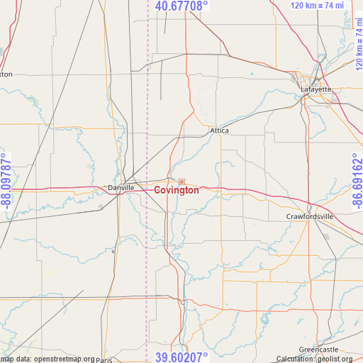
Covington GPS coordinates[2]
40° 8' 30.12" North, 87° 23' 41.064" West
| Map corner | latitude | longitude |
|---|---|---|
| Upper-left | 40.67708°, | -88.09787° |
| Center: | 40.1417°, | -87.39474° |
| Lower-right: | 39.60207°, | -86.69162° |
| Map W x H: | 119.5×119.5 km | = 74.3×74.3mi |
| max Lat: | 71.29058° ⇑45% North |
| Covington: | 40.1417° |
| min Lat: | ⇓55% South 19.06759° |
| min Long | Covington | max Long |
| -171.73463° | -87.39474° | -66.98998° |
| W 49.4%⇐ | ⇒50.6% E |
Elevation
Elevation of Covington is 177 m = 581 ft, and this is 117.8 m = 386 ft below average elevation for this country.
| Max E: |
3189 m = 10463 ft | 55.7% |
| Avg. | 294.8 m = 967 ft | |
| Covington | 177 m = 581 ft | |
Min E: |
-60 m = -197 ft | 44.3% |
See also: United States elevation on elevation.city.
Geographical zone
Covington is located in North temperate zone (between Tropic of Cancer and the Arctic Circle). Distance of this Northern Tropic circle is 1857.4 km =1154.1 mi to South.| Distance of | km | miles | from Covington |
|---|---|---|---|
| North Pole | 5543.7 | 3444.7 | to North |
| Arctic Circle | 2937.8 | 1825.5 | to North |
| Tropic Cancer | 1857.4 | 1154.1 | to South |
| Equator | 4463.3 | 2773.4 | to South |


Nearby cities:
15 places around Covington: (largest is in red/bold)
• Attica
21 km =13 mi,  36°
36°
• Bismarck
22.6 km =14 mi,  306°
306°
• Catlin
27.5 km =17.1 mi,  251°
251°
• Cayuga
22.2 km =13.8 mi,  194°
194°
• Danville
20.1 km =12.5 mi,  264°
264°
• Georgetown
27.6 km =17.1 mi,  227°
227°
• Hillsboro
18.2 km =11.3 mi,  101°
101°
• Newport
28.7 km =17.8 mi,  182°
182°
• Rockport
30.6 km =19 mi,  161°
161°
• Tilton
22.1 km =13.7 mi, 256°
• Veedersburg
11.7 km =7.3 mi,  105°
105°
• Waynetown
29.1 km =18.1 mi, 101°
• West Lebanon
14.3 km =8.9 mi,  2°
2°
• Westville
23.5 km =14.6 mi,  241°
241°
• Williamsport
18.4 km =11.4 mi,  27°
27°
Sources, notices
• [Note1] Compared only with cities in United States existing in our database
• [Src1] Map data: © OpenStreetMap contributors (CC-BY-SA)
• [Src2] Other city data from geonames.org with taken over terms of usage.
• [Src3] Geographical zone / Annual Mean Temperature by Robert A. Rohde @ Wikipedia
