Yorkville geodata
Yorkville (Illinois) is a seat of a second-order administrative division; located in United States in America/Chicago (GMT-5) time zone. With population of 18,451 people, there are 2720 cities with bigger population in this country. Compared to other cities in United States, 72.3% of cities are located further ↓South; 54.6% of cities are located further →East and 51.9% of cities have higher elevation than Yorkville. Note1


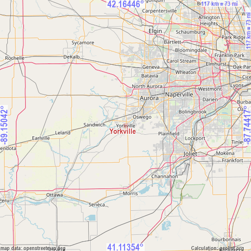
Yorkville GPS coordinates[2]
41° 38' 28.104" North, 88° 26' 50.244" West
| Map corner | latitude | longitude |
|---|---|---|
| Upper-left | 42.16446°, | -89.15042° |
| Center: | 41.64114°, | -88.44729° |
| Lower-right: | 41.11354°, | -87.74417° |
| Map W x H: | 116.9×116.9 km | = 72.6×72.6mi |
| max Lat: | 71.29058° ⇑27.7% North |
| Yorkville: | 41.64114° |
| min Lat: | ⇓72.3% South 19.06759° |
| min Long | Yorkville | max Long |
| -171.73463° | -88.44729° | -66.98998° |
| W 45.4%⇐ | ⇒54.6% E |
Elevation
Elevation of Yorkville is 191 m = 627 ft, and this is 103.8 m = 341 ft below average elevation for this country.
| Max E: |
3189 m = 10463 ft | 51.9% |
| Avg. | 294.8 m = 967 ft | |
| Yorkville | 191 m = 627 ft | |
Min E: |
-60 m = -197 ft | 48.1% |
See also: United States elevation on elevation.city.
Geographical zone
Yorkville is located in North temperate zone (between Tropic of Cancer and the Arctic Circle). Distance of this Northern Tropic circle is 2024.1 km =1257.7 mi to South.| Distance of | km | miles | from Yorkville |
|---|---|---|---|
| North Pole | 5377 | 3341.1 | to North |
| Arctic Circle | 2771.1 | 1721.9 | to North |
| Tropic Cancer | 2024.1 | 1257.7 | to South |
| Equator | 4630.1 | 2877 | to South |


Nearby cities:
15 places around Yorkville: (largest is in red/bold)
• Aurora
17 km =10.6 mi,  38°
38°
• Big Rock
16 km =9.9 mi,  328°
328°
• Boulder Hill
12.2 km =7.6 mi,  49°
49°
• Lake Holiday
18.9 km =11.7 mi,  260°
260°
• Lynwood
6.5 km =4 mi, 43°
• Millington
15.3 km =9.5 mi,  235°
235°
• Montgomery
13 km =8.1 mi, 40°
• Newark
16.2 km =10.1 mi,  224°
224°
• Oswego
9.2 km =5.7 mi,  59°
59°
• Plainfield
20.3 km =12.6 mi,  94°
94°
• Plano
7.8 km =4.8 mi,  287°
287°
• Prestbury
16 km =9.9 mi,  8°
8°
• Sandwich
14.5 km =9 mi,  272°
272°
• Somonauk
19.5 km =12.1 mi, 267°
• Sugar Grove
13.4 km =8.3 mi,  1°
1°
Sources, notices
• [Note1] Compared only with cities in United States existing in our database
• [Src1] Map data: © OpenStreetMap contributors (CC-BY-SA)
• [Src2] Other city data from geonames.org with taken over terms of usage.
• [Src3] Geographical zone / Annual Mean Temperature by Robert A. Rohde @ Wikipedia
