Anderson geodata
Anderson (Indiana) is a seat of a second-order administrative division; located in United States in America/Indiana/Indianapolis (GMT-4) time zone. With population of 55,305 people, there are 834 cities with bigger population in this country. Compared to other cities in United States, 54.6% of cities are located further ↓South; 53.9% of cities are located further ←West and 67.8% of cities have lower elevation than Anderson. Note1


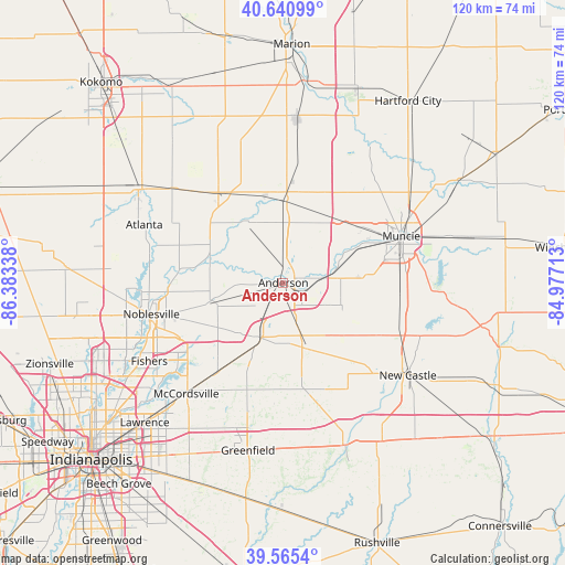
Anderson GPS coordinates[2]
40° 6' 19.152" North, 85° 40' 48.9" West
| Map corner | latitude | longitude |
|---|---|---|
| Upper-left | 40.64099°, | -86.38338° |
| Center: | 40.10532°, | -85.68025° |
| Lower-right: | 39.5654°, | -84.97713° |
| Map W x H: | 119.6×119.6 km | = 74.3×74.3mi |
| max Lat: | 71.29058° ⇑45.4% North |
| Anderson: | 40.10532° |
| min Lat: | ⇓54.6% South 19.06759° |
| min Long | Anderson | max Long |
| -171.73463° | -85.68025° | -66.98998° |
| W 53.9%⇐ | ⇒46.1% E |
Elevation
Elevation of Anderson is 275 m = 902 ft, and this is 19.8 m = 65 ft below average elevation for this country.
| Max E: |
3189 m = 10463 ft | 32.2% |
| Avg. | 294.8 m = 967 ft | |
| Anderson | 275 m = 902 ft | |
Min E: |
-60 m = -197 ft | 67.8% |
See also: Anderson elevation on elevation.city.
Geographical zone
Anderson is located in North temperate zone (between Tropic of Cancer and the Arctic Circle). Distance of this Northern Tropic circle is 1853.4 km =1151.6 mi to South.| Distance of | km | miles | from Anderson |
|---|---|---|---|
| North Pole | 5547.8 | 3447.2 | to North |
| Arctic Circle | 2941.9 | 1828 | to North |
| Tropic Cancer | 1853.4 | 1151.6 | to South |
| Equator | 4459.3 | 2770.9 | to South |


Nearby cities:
15 places around Anderson: (largest is in red/bold)
• Alexandria
17.5 km =10.9 mi,  1°
1°
• Chesterfield
7.1 km =4.4 mi,  83°
83°
• Daleville
10.5 km =6.5 mi, 80°
• Edgewood
4.6 km =2.9 mi,  267°
267°
• Elwood
23.5 km =14.6 mi,  324°
324°
• Fortville
24 km =14.9 mi,  216°
216°
• Frankton
15.5 km =9.6 mi,  327°
327°
• Ingalls
19.6 km =12.2 mi,  212°
212°
• Lapel
14.9 km =9.3 mi,  253°
253°
• Markleville
15.2 km =9.4 mi,  158°
158°
• Middletown
13.3 km =8.3 mi,  113°
113°
• Pendleton
13.2 km =8.2 mi, 205°
• Shirley
25.3 km =15.7 mi, 159°
• Summitville
26.1 km =16.2 mi,  6°
6°
• Yorktown
17.5 km =10.9 mi,  64°
64°
Sources, notices
• [Note1] Compared only with cities in United States existing in our database
• [Src1] Map data: © OpenStreetMap contributors (CC-BY-SA)
• [Src2] Other city data from geonames.org with taken over terms of usage.
• [Src3] Geographical zone / Annual Mean Temperature by Robert A. Rohde @ Wikipedia
