Lapel geodata
Lapel (Indiana) is a populated place; located in United States in America/Indiana/Indianapolis (GMT-4) time zone. With population of 2,053 people, there are 11775 cities with bigger population in this country. Compared to other cities in United States, 54.2% of cities are located further ↓South; 53.3% of cities are located further ←West and 64.8% of cities have lower elevation than Lapel. Note1
Administrative division(s):
- Level 1: Indiana
- Level 2: Madison County
- Level 3: Township of Stony Creek


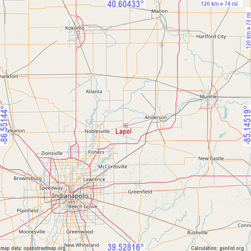
Lapel GPS coordinates[2]
40° 4' 6.132" North, 85° 50' 53.916" West
| Map corner | latitude | longitude |
|---|---|---|
| Upper-left | 40.60433°, | -86.55144° |
| Center: | 40.06837°, | -85.84831° |
| Lower-right: | 39.52816°, | -85.14519° |
| Map W x H: | 119.7×119.7 km | = 74.4×74.4mi |
| max Lat: | 71.29058° ⇑45.8% North |
| Lapel: | 40.06837° |
| min Lat: | ⇓54.2% South 19.06759° |
| min Long | Lapel | max Long |
| -171.73463° | -85.84831° | -66.98998° |
| W 53.3%⇐ | ⇒46.7% E |
Elevation
Elevation of Lapel is 261 m = 856 ft, and this is 33.8 m = 111 ft below average elevation for this country.
| Max E: |
3189 m = 10463 ft | 35.2% |
| Avg. | 294.8 m = 967 ft | |
| Lapel | 261 m = 856 ft | |
Min E: |
-60 m = -197 ft | 64.8% |
See also: United States elevation on elevation.city.
Geographical zone
Lapel is located in North temperate zone (between Tropic of Cancer and the Arctic Circle). Distance of this Northern Tropic circle is 1849.3 km =1149.1 mi to South.| Distance of | km | miles | from Lapel |
|---|---|---|---|
| North Pole | 5551.9 | 3449.8 | to North |
| Arctic Circle | 2946 | 1830.6 | to North |
| Tropic Cancer | 1849.3 | 1149.1 | to South |
| Equator | 4455.2 | 2768.3 | to South |


Nearby cities:
15 places around Lapel: (largest is in red/bold)
• Anderson
14.9 km =9.3 mi,  73°
73°
• Arcadia
19 km =11.8 mi,  309°
309°
• Atlanta
22.3 km =13.9 mi,  317°
317°
• Chesterfield
21.9 km =13.6 mi,  77°
77°
• Cicero
15.3 km =9.5 mi,  293°
293°
• Edgewood
10.5 km =6.5 mi, 68°
• Elwood
23.2 km =14.4 mi,  1°
1°
• Fishers
18.9 km =11.7 mi,  228°
228°
• Fortville
15.1 km =9.4 mi,  179°
179°
• Frankton
18.2 km =11.3 mi,  18°
18°
• Ingalls
12.9 km =8 mi,  163°
163°
• Markleville
22.3 km =13.9 mi,  116°
116°
• McCordsville
18.9 km =11.7 mi,  199°
199°
• Noblesville
13.9 km =8.6 mi,  259°
259°
• Pendleton
11.7 km =7.3 mi,  132°
132°
Sources, notices
• [Note1] Compared only with cities in United States existing in our database
• [Src1] Map data: © OpenStreetMap contributors (CC-BY-SA)
• [Src2] Other city data from geonames.org with taken over terms of usage.
• [Src3] Geographical zone / Annual Mean Temperature by Robert A. Rohde @ Wikipedia
