Elkhart geodata
Elkhart (Indiana) is a populated place; located in United States in America/Indiana/Indianapolis (GMT-4) time zone. With population of 52,348 people, there are 897 cities with bigger population in this country. Compared to other cities in United States, 72.7% of cities are located further ↓South; 52.9% of cities are located further ←West and 58.4% of cities have lower elevation than Elkhart. Note1


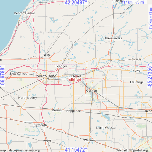
Elkhart GPS coordinates[2]
41° 40' 55.164" North, 85° 58' 36.012" West
| Map corner | latitude | longitude |
|---|---|---|
| Upper-left | 42.20497°, | -86.6798° |
| Center: | 41.68199°, | -85.97667° |
| Lower-right: | 41.15472°, | -85.27355° |
| Map W x H: | 116.8×116.8 km | = 72.6×72.6mi |
| max Lat: | 71.29058° ⇑27.3% North |
| Elkhart: | 41.68199° |
| min Lat: | ⇓72.7% South 19.06759° |
| min Long | Elkhart | max Long |
| -171.73463° | -85.97667° | -66.98998° |
| W 52.9%⇐ | ⇒47.1% E |
Elevation
Elevation of Elkhart is 232 m = 761 ft, and this is 62.8 m = 206 ft below average elevation for this country.
| Max E: |
3189 m = 10463 ft | 41.6% |
| Avg. | 294.8 m = 967 ft | |
| Elkhart | 232 m = 761 ft | |
Min E: |
-60 m = -197 ft | 58.4% |
See also: Elkhart elevation on elevation.city.
Geographical zone
Elkhart is located in North temperate zone (between Tropic of Cancer and the Arctic Circle). Distance of this Northern Tropic circle is 2028.7 km =1260.6 mi to South.| Distance of | km | miles | from Elkhart |
|---|---|---|---|
| North Pole | 5372.5 | 3338.3 | to North |
| Arctic Circle | 2766.6 | 1719.1 | to North |
| Tropic Cancer | 2028.7 | 1260.6 | to South |
| Equator | 4634.6 | 2879.8 | to South |


Nearby cities:
15 places around Elkhart: (largest is in red/bold)
• Bristol
13.9 km =8.6 mi,  71°
71°
• Dunlap
6.7 km =4.2 mi,  137°
137°
• Edwardsburg
15.3 km =9.5 mi,  325°
325°
• Georgetown
21.5 km =13.4 mi,  284°
284°
• Goshen
16.2 km =10.1 mi,  133°
133°
• Granger
13.7 km =8.5 mi,  305°
305°
• Gulivoire Park
23.6 km =14.7 mi,  251°
251°
• Middlebury
22.5 km =14 mi,  91°
91°
• Mishawaka
15.3 km =9.5 mi,  261°
261°
• Notre Dame
21.8 km =13.5 mi, 275°
• Osceola
8.4 km =5.2 mi, 257°
• Roseland
23.2 km =14.4 mi, 279°
• Simonton Lake
8 km =5 mi,  0°
0°
• South Bend
22.7 km =14.1 mi,  270°
270°
• Wakarusa
16.6 km =10.3 mi,  192°
192°
Sources, notices
• [Note1] Compared only with cities in United States existing in our database
• [Src1] Map data: © OpenStreetMap contributors (CC-BY-SA)
• [Src2] Other city data from geonames.org with taken over terms of usage.
• [Src3] Geographical zone / Annual Mean Temperature by Robert A. Rohde @ Wikipedia
