Mishawaka geodata
Mishawaka (Indiana) is a populated place; located in United States in America/Indiana/Indianapolis (GMT-4) time zone. With population of 48,261 people, there are 996 cities with bigger population in this country. Compared to other cities in United States, 72.5% of cities are located further ↓South; 52.4% of cities are located further ←West and 55.4% of cities have lower elevation than Mishawaka. Note1


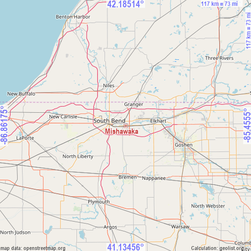
Mishawaka GPS coordinates[2]
41° 39' 43.164" North, 86° 9' 31.032" West
| Map corner | latitude | longitude |
|---|---|---|
| Upper-left | 42.18514°, | -86.86175° |
| Center: | 41.66199°, | -86.15862° |
| Lower-right: | 41.13456°, | -85.4555° |
| Map W x H: | 116.8×116.8 km | = 72.6×72.6mi |
| max Lat: | 71.29058° ⇑27.5% North |
| Mishawaka: | 41.66199° |
| min Lat: | ⇓72.5% South 19.06759° |
| min Long | Mishawaka | max Long |
| -171.73463° | -86.15862° | -66.98998° |
| W 52.4%⇐ | ⇒47.6% E |
Elevation
Elevation of Mishawaka is 220 m = 722 ft, and this is 74.8 m = 245 ft below average elevation for this country.
| Max E: |
3189 m = 10463 ft | 44.6% |
| Avg. | 294.8 m = 967 ft | |
| Mishawaka | 220 m = 722 ft | |
Min E: |
-60 m = -197 ft | 55.4% |
See also: Mishawaka elevation on elevation.city.
Geographical zone
Mishawaka is located in North temperate zone (between Tropic of Cancer and the Arctic Circle). Distance of this Northern Tropic circle is 2026.5 km =1259.2 mi to South.| Distance of | km | miles | from Mishawaka |
|---|---|---|---|
| North Pole | 5374.7 | 3339.7 | to North |
| Arctic Circle | 2768.8 | 1720.5 | to North |
| Tropic Cancer | 2026.5 | 1259.2 | to South |
| Equator | 4632.4 | 2878.4 | to South |


Nearby cities:
15 places around Mishawaka: (largest is in red/bold)
• Bremen
24 km =14.9 mi,  177°
177°
• Dunlap
19.9 km =12.4 mi,  97°
97°
• Edwardsburg
16.2 km =10.1 mi,  23°
23°
• Elkhart
15.3 km =9.5 mi,  81°
81°
• Georgetown
9.5 km =5.9 mi,  322°
322°
• Granger
10.9 km =6.8 mi, 21°
• Gulivoire Park
9 km =5.6 mi,  233°
233°
• Lakeville
18 km =11.2 mi,  211°
211°
• Niles
20.3 km =12.6 mi,  336°
336°
• Notre Dame
7.8 km =4.8 mi,  302°
302°
• Osceola
6.9 km =4.3 mi,  87°
87°
• Roseland
9.9 km =6.2 mi,  307°
307°
• Simonton Lake
18.4 km =11.4 mi,  56°
56°
• South Bend
8 km =5 mi,  287°
287°
• Wakarusa
18.1 km =11.2 mi,  140°
140°
Sources, notices
• [Note1] Compared only with cities in United States existing in our database
• [Src1] Map data: © OpenStreetMap contributors (CC-BY-SA)
• [Src2] Other city data from geonames.org with taken over terms of usage.
• [Src3] Geographical zone / Annual Mean Temperature by Robert A. Rohde @ Wikipedia
