Dunlap geodata
Dunlap (Indiana) is a populated place; located in United States in America/Indiana/Indianapolis (GMT-4) time zone. With population of 6,235 people, there are 6250 cities with bigger population in this country. Compared to other cities in United States, 72.2% of cities are located further ↓South; 53.1% of cities are located further ←West and 59.6% of cities have lower elevation than Dunlap. Note1


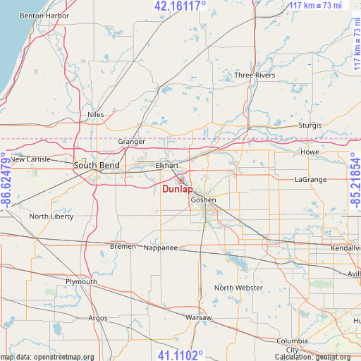
Dunlap GPS coordinates[2]
41° 38' 16.188" North, 85° 55' 17.976" West
| Map corner | latitude | longitude |
|---|---|---|
| Upper-left | 42.16117°, | -86.62479° |
| Center: | 41.63783°, | -85.92166° |
| Lower-right: | 41.1102°, | -85.21854° |
| Map W x H: | 116.9×116.9 km | = 72.6×72.6mi |
| max Lat: | 71.29058° ⇑27.8% North |
| Dunlap: | 41.63783° |
| min Lat: | ⇓72.2% South 19.06759° |
| min Long | Dunlap | max Long |
| -171.73463° | -85.92166° | -66.98998° |
| W 53.1%⇐ | ⇒46.9% E |
Elevation
Elevation of Dunlap is 238 m = 781 ft, and this is 56.8 m = 186 ft below average elevation for this country.
| Max E: |
3189 m = 10463 ft | 40.4% |
| Avg. | 294.8 m = 967 ft | |
| Dunlap | 238 m = 781 ft | |
Min E: |
-60 m = -197 ft | 59.6% |
See also: United States elevation on elevation.city.
Geographical zone
Dunlap is located in North temperate zone (between Tropic of Cancer and the Arctic Circle). Distance of this Northern Tropic circle is 2023.8 km =1257.5 mi to South.| Distance of | km | miles | from Dunlap |
|---|---|---|---|
| North Pole | 5377.4 | 3341.4 | to North |
| Arctic Circle | 2771.5 | 1722.1 | to North |
| Tropic Cancer | 2023.8 | 1257.5 | to South |
| Equator | 4629.7 | 2876.8 | to South |


Nearby cities:
15 places around Dunlap: (largest is in red/bold)
• Bristol
12.7 km =7.9 mi,  42°
42°
• Edwardsburg
22 km =13.7 mi,  323°
323°
• Elkhart
6.7 km =4.2 mi, 317°
• Goshen
9.5 km =5.9 mi,  130°
130°
• Granger
20.3 km =12.6 mi,  309°
309°
• Gulivoire Park
27 km =16.8 mi,  264°
264°
• Middlebury
18.4 km =11.4 mi,  76°
76°
• Milford
26.1 km =16.2 mi,  165°
165°
• Millersburg
22.5 km =14 mi,  122°
122°
• Mishawaka
19.9 km =12.4 mi,  277°
277°
• Nappanee
22.7 km =14.1 mi,  197°
197°
• New Paris
17.2 km =10.7 mi,  153°
153°
• Osceola
13.2 km =8.2 mi, 283°
• Simonton Lake
13.7 km =8.5 mi,  341°
341°
• Wakarusa
14 km =8.7 mi,  216°
216°
Sources, notices
• [Note1] Compared only with cities in United States existing in our database
• [Src1] Map data: © OpenStreetMap contributors (CC-BY-SA)
• [Src2] Other city data from geonames.org with taken over terms of usage.
• [Src3] Geographical zone / Annual Mean Temperature by Robert A. Rohde @ Wikipedia
