Edwardsburg geodata
Edwardsburg (Michigan) is a populated place; located in United States in America/Detroit (GMT-4) time zone. With population of 1,227 people, there are 14971 cities with bigger population in this country. Compared to other cities in United States, 73.9% of cities are located further ↓South; 52.7% of cities are located further ←West and 63.1% of cities have lower elevation than Edwardsburg. Note1


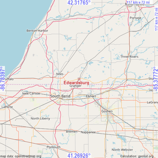
Edwardsburg GPS coordinates[2]
41° 47' 44.16" North, 86° 4' 51.024" West
| Map corner | latitude | longitude |
|---|---|---|
| Upper-left | 42.31765°, | -86.78397° |
| Center: | 41.7956°, | -86.08084° |
| Lower-right: | 41.26926°, | -85.37772° |
| Map W x H: | 116.6×116.6 km | = 72.5×72.5mi |
| max Lat: | 71.29058° ⇑26.1% North |
| Edwardsburg: | 41.7956° |
| min Lat: | ⇓73.9% South 19.06759° |
| min Long | Edwardsburg | max Long |
| -171.73463° | -86.08084° | -66.98998° |
| W 52.7%⇐ | ⇒47.3% E |
Elevation
Elevation of Edwardsburg is 253 m = 830 ft, and this is 41.8 m = 137 ft below average elevation for this country.
| Max E: |
3189 m = 10463 ft | 36.9% |
| Avg. | 294.8 m = 967 ft | |
| Edwardsburg | 253 m = 830 ft | |
Min E: |
-60 m = -197 ft | 63.1% |
See also: United States elevation on elevation.city.
Geographical zone
Edwardsburg is located in North temperate zone (between Tropic of Cancer and the Arctic Circle). Distance of this Northern Tropic circle is 2041.3 km =1268.4 mi to South.| Distance of | km | miles | from Edwardsburg |
|---|---|---|---|
| North Pole | 5359.8 | 3330.4 | to North |
| Arctic Circle | 2753.9 | 1711.2 | to North |
| Tropic Cancer | 2041.3 | 1268.4 | to South |
| Equator | 4647.2 | 2887.6 | to South |


Nearby cities:
15 places around Edwardsburg: (largest is in red/bold)
• Bristol
23.3 km =14.5 mi,  110°
110°
• Buchanan
23.5 km =14.6 mi,  278°
278°
• Cassopolis
14.2 km =8.8 mi,  24°
24°
• Dowagiac
21.1 km =13.1 mi,  353°
353°
• Dunlap
22 km =13.7 mi,  143°
143°
• Elkhart
15.3 km =9.5 mi,  145°
145°
• Georgetown
14.3 km =8.9 mi,  238°
238°
• Granger
5.3 km =3.3 mi,  207°
207°
• Mishawaka
16.2 km =10.1 mi,  203°
203°
• Niles
14.9 km =9.3 mi, 284°
• Notre Dame
16.8 km =10.4 mi,  230°
230°
• Osceola
14.5 km =9 mi,  178°
178°
• Roseland
16.8 km =10.4 mi, 238°
• Simonton Lake
9.9 km =6.2 mi,  117°
117°
• South Bend
18.8 km =11.7 mi, 228°
Sources, notices
• [Note1] Compared only with cities in United States existing in our database
• [Src1] Map data: © OpenStreetMap contributors (CC-BY-SA)
• [Src2] Other city data from geonames.org with taken over terms of usage.
• [Src3] Geographical zone / Annual Mean Temperature by Robert A. Rohde @ Wikipedia
