Roseland geodata
Roseland (Indiana) is a populated place; located in United States in America/Indiana/Indianapolis (GMT-4) time zone. With population of 628 people, there are 19375 cities with bigger population in this country. Compared to other cities in United States, 73.1% of cities are located further ↓South; 52.2% of cities are located further ←West and 56.7% of cities have lower elevation than Roseland. Note1


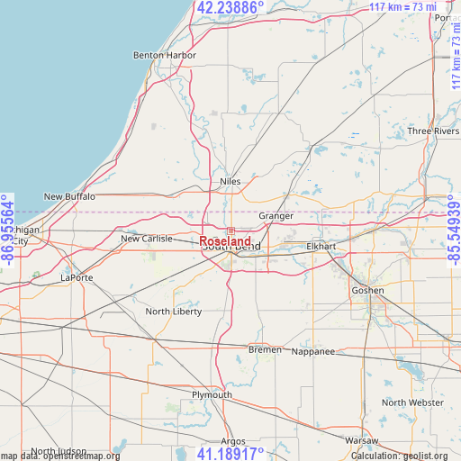
Roseland GPS coordinates[2]
41° 42' 58.176" North, 86° 15' 9.036" West
| Map corner | latitude | longitude |
|---|---|---|
| Upper-left | 42.23886°, | -86.95564° |
| Center: | 41.71616°, | -86.25251° |
| Lower-right: | 41.18917°, | -85.54939° |
| Map W x H: | 116.7×116.7 km | = 72.5×72.5mi |
| max Lat: | 71.29058° ⇑26.9% North |
| Roseland: | 41.71616° |
| min Lat: | ⇓73.1% South 19.06759° |
| min Long | Roseland | max Long |
| -171.73463° | -86.25251° | -66.98998° |
| W 52.2%⇐ | ⇒47.8% E |
Elevation
Elevation of Roseland is 225 m = 738 ft, and this is 69.8 m = 229 ft below average elevation for this country.
| Max E: |
3189 m = 10463 ft | 43.3% |
| Avg. | 294.8 m = 967 ft | |
| Roseland | 225 m = 738 ft | |
Min E: |
-60 m = -197 ft | 56.7% |
See also: United States elevation on elevation.city.
Geographical zone
Roseland is located in North temperate zone (between Tropic of Cancer and the Arctic Circle). Distance of this Northern Tropic circle is 2032.5 km =1262.9 mi to South.| Distance of | km | miles | from Roseland |
|---|---|---|---|
| North Pole | 5368.7 | 3336 | to North |
| Arctic Circle | 2762.8 | 1716.7 | to North |
| Tropic Cancer | 2032.5 | 1262.9 | to South |
| Equator | 4638.4 | 2882.2 | to South |


Nearby cities:
15 places around Roseland: (largest is in red/bold)
• Buchanan
15.3 km =9.5 mi,  323°
323°
• Edwardsburg
16.8 km =10.4 mi,  58°
58°
• Elkhart
23.2 km =14.4 mi,  99°
99°
• Galien
22.4 km =13.9 mi,  294°
294°
• Georgetown
2.5 km =1.6 mi,  53°
53°
• Granger
12.5 km =7.8 mi,  70°
70°
• Gulivoire Park
11.4 km =7.1 mi,  176°
176°
• Lakeville
21.4 km =13.3 mi, 184°
• Mishawaka
9.9 km =6.2 mi,  127°
127°
• New Carlisle
21.4 km =13.3 mi,  265°
265°
• Niles
12.6 km =7.8 mi,  359°
359°
• Notre Dame
2.1 km =1.3 mi,  145°
145°
• Osceola
15.7 km =9.8 mi,  111°
111°
• Simonton Lake
23.4 km =14.5 mi,  79°
79°
• South Bend
3.7 km =2.3 mi, 176°
Sources, notices
• [Note1] Compared only with cities in United States existing in our database
• [Src1] Map data: © OpenStreetMap contributors (CC-BY-SA)
• [Src2] Other city data from geonames.org with taken over terms of usage.
• [Src3] Geographical zone / Annual Mean Temperature by Robert A. Rohde @ Wikipedia
