Tri-Lakes geodata
Tri-Lakes (Indiana) is a populated place; located in United States in America/Indiana/Indianapolis (GMT-4) time zone. With population of 1,421 people, there are 14009 cities with bigger population in this country. Compared to other cities in United States, 68.2% of cities are located further ↓South; 54.8% of cities are located further ←West and 70.1% of cities have lower elevation than Tri-Lakes. Note1
Administrative division(s):
- Level 1: Indiana
- Level 2: Whitley County
- Level 3: Township of Thorncreek


Tri-Lakes GPS coordinates[2]
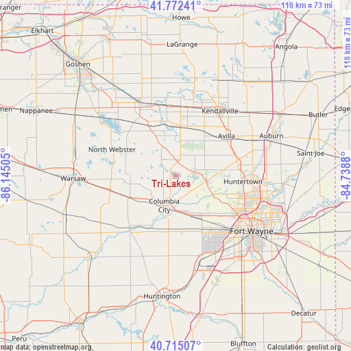
41° 14' 45.168" North, 85° 26' 30.912" West
| Map corner | latitude | longitude |
|---|---|---|
| Upper-left | 41.77241°, | -86.14505° |
| Center: | 41.24588°, | -85.44192° |
| Lower-right: | 40.71507°, | -84.7388° |
| Map W x H: | 117.6×117.6 km | = 73.1×73.1mi |
| max Lat: | 71.29058° ⇑31.8% North |
| Tri-Lakes: | 41.24588° |
| min Lat: | ⇓68.2% South 19.06759° |
| min Long | Tri-Lakes | max Long |
| -171.73463° | -85.44192° | -66.98998° |
| W 54.8%⇐ | ⇒45.2% E |
Elevation
Elevation of Tri-Lakes is 286 m = 938 ft, and this is 8.8 m = 29 ft below average elevation for this country.
| Max E: |
3189 m = 10463 ft | 29.9% |
| Avg. | 294.8 m = 967 ft | |
| Tri-Lakes | 286 m = 938 ft | |
Min E: |
-60 m = -197 ft | 70.1% |
See also: United States elevation on elevation.city.
Geographical zone
Tri-Lakes is located in North temperate zone (between Tropic of Cancer and the Arctic Circle). Distance of this Northern Tropic circle is 1980.2 km =1230.4 mi to South.| Distance of | km | miles | from Tri-Lakes |
|---|---|---|---|
| North Pole | 5420.9 | 3368.4 | to North |
| Arctic Circle | 2815.1 | 1749.2 | to North |
| Tropic Cancer | 1980.2 | 1230.4 | to South |
| Equator | 4586.1 | 2849.7 | to South |


Nearby cities:
15 places around Tri-Lakes: (largest is in red/bold)
• Albion
16.7 km =10.4 mi,  5°
5°
• Avilla
21.6 km =13.4 mi,  51°
51°
• Churubusco
10.4 km =6.5 mi,  99°
99°
• Columbia City
10.6 km =6.6 mi,  201°
201°
• Cromwell
22.5 km =14 mi,  319°
319°
• Fort Wayne
29.2 km =18.1 mi,  116°
116°
• Garrett
28.1 km =17.5 mi,  65°
65°
• Huntertown
22.6 km =14 mi,  94°
94°
• Kendallville
26.3 km =16.3 mi,  34°
34°
• Ligonier
27.3 km =17 mi,  333°
333°
• North Webster
23.1 km =14.4 mi,  292°
292°
• Pierceton
22.6 km =14 mi,  257°
257°
• Rome City
28.4 km =17.6 mi, 11°
• South Whitley
23.7 km =14.7 mi,  221°
221°
• Wolcottville
31.8 km =19.8 mi, 11°
Sources, notices
• [Note1] Compared only with cities in United States existing in our database
• [Src1] Map data: © OpenStreetMap contributors (CC-BY-SA)
• [Src2] Other city data from geonames.org with taken over terms of usage.
• [Src3] Geographical zone / Annual Mean Temperature by Robert A. Rohde @ Wikipedia
