Otterbein geodata
Otterbein (Indiana) is a populated place; located in United States in America/Indiana/Indianapolis (GMT-4) time zone. With population of 1,254 people, there are 14828 cities with bigger population in this country. Compared to other cities in United States, 58.8% of cities are located further ↓South; 50.1% of cities are located further ←West and 54.4% of cities have lower elevation than Otterbein. Note1


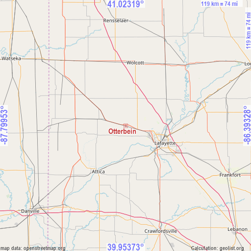
Otterbein GPS coordinates[2]
40° 29' 26.124" North, 87° 5' 47.04" West
| Map corner | latitude | longitude |
|---|---|---|
| Upper-left | 41.02319°, | -87.79953° |
| Center: | 40.49059°, | -87.0964° |
| Lower-right: | 39.95373°, | -86.39328° |
| Map W x H: | 118.9×118.9 km | = 73.9×73.9mi |
| max Lat: | 71.29058° ⇑41.2% North |
| Otterbein: | 40.49059° |
| min Lat: | ⇓58.8% South 19.06759° |
| min Long | Otterbein | max Long |
| -171.73463° | -87.0964° | -66.98998° |
| W 50.1%⇐ | ⇒49.9% E |
Elevation
Elevation of Otterbein is 216 m = 709 ft, and this is 78.8 m = 259 ft below average elevation for this country.
| Max E: |
3189 m = 10463 ft | 45.6% |
| Avg. | 294.8 m = 967 ft | |
| Otterbein | 216 m = 709 ft | |
Min E: |
-60 m = -197 ft | 54.4% |
See also: United States elevation on elevation.city.
Geographical zone
Otterbein is located in North temperate zone (between Tropic of Cancer and the Arctic Circle). Distance of this Northern Tropic circle is 1896.2 km =1178.2 mi to South.| Distance of | km | miles | from Otterbein |
|---|---|---|---|
| North Pole | 5504.9 | 3420.6 | to North |
| Arctic Circle | 2899 | 1801.4 | to North |
| Tropic Cancer | 1896.2 | 1178.2 | to South |
| Equator | 4502.1 | 2797.5 | to South |


Nearby cities:
15 places around Otterbein: (largest is in red/bold)
• Attica
25.4 km =15.8 mi,  210°
210°
• Battle Ground
21.6 km =13.4 mi,  84°
84°
• Boswell
24.1 km =15 mi,  278°
278°
• Brookston
23 km =14.3 mi,  57°
57°
• Chalmers
27.1 km =16.8 mi,  44°
44°
• Dayton
30.6 km =19 mi,  115°
115°
• Fowler
23.6 km =14.7 mi,  306°
306°
• Lafayette
20.4 km =12.7 mi,  113°
113°
• Oxford
13.2 km =8.2 mi, 284°
• Remington
30.4 km =18.9 mi,  351°
351°
• Shadeland
18 km =11.2 mi,  136°
136°
• West Lafayette
17.5 km =10.9 mi, 114°
• Westpoint
16.8 km =10.4 mi,  164°
164°
• Williamsport
28 km =17.4 mi,  216°
216°
• Wolcott
30.1 km =18.7 mi,  8°
8°
Sources, notices
• [Note1] Compared only with cities in United States existing in our database
• [Src1] Map data: © OpenStreetMap contributors (CC-BY-SA)
• [Src2] Other city data from geonames.org with taken over terms of usage.
• [Src3] Geographical zone / Annual Mean Temperature by Robert A. Rohde @ Wikipedia
