Westpoint geodata
Westpoint (Indiana) is a populated place; located in United States in America/Indiana/Indianapolis (GMT-4) time zone. With population of 594 people, there are 19769 cities with bigger population in this country. Compared to other cities in United States, 57.2% of cities are located further ↓South; 50.2% of cities are located further ←West and 52.2% of cities have lower elevation than Westpoint. Note1


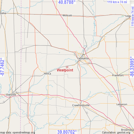
Westpoint GPS coordinates[2]
40° 20' 42.144" North, 87° 2' 35.052" West
| Map corner | latitude | longitude |
|---|---|---|
| Upper-left | 40.8788°, | -87.7462° |
| Center: | 40.34504°, | -87.04307° |
| Lower-right: | 39.80702°, | -86.33995° |
| Map W x H: | 119.2×119.2 km | = 74.1×74.1mi |
| max Lat: | 71.29058° ⇑42.8% North |
| Westpoint: | 40.34504° |
| min Lat: | ⇓57.2% South 19.06759° |
| min Long | Westpoint | max Long |
| -171.73463° | -87.04307° | -66.98998° |
| W 50.2%⇐ | ⇒49.8% E |
Elevation
Elevation of Westpoint is 207 m = 679 ft, and this is 87.8 m = 288 ft below average elevation for this country.
| Max E: |
3189 m = 10463 ft | 47.8% |
| Avg. | 294.8 m = 967 ft | |
| Westpoint | 207 m = 679 ft | |
Min E: |
-60 m = -197 ft | 52.2% |
See also: United States elevation on elevation.city.
Geographical zone
Westpoint is located in North temperate zone (between Tropic of Cancer and the Arctic Circle). Distance of this Northern Tropic circle is 1880 km =1168.2 mi to South.| Distance of | km | miles | from Westpoint |
|---|---|---|---|
| North Pole | 5521.1 | 3430.7 | to North |
| Arctic Circle | 2915.2 | 1811.4 | to North |
| Tropic Cancer | 1880 | 1168.2 | to South |
| Equator | 4485.9 | 2787.4 | to South |


Nearby cities:
15 places around Westpoint: (largest is in red/bold)
• Attica
18.3 km =11.4 mi,  252°
252°
• Battle Ground
24.9 km =15.5 mi,  43°
43°
• Clarks Hill
29.1 km =18.1 mi,  112°
112°
• Dayton
23.5 km =14.6 mi,  82°
82°
• Hillsboro
28.9 km =18 mi,  204°
204°
• Lafayette
16.3 km =10.1 mi,  60°
60°
• Linden
21.1 km =13.1 mi,  145°
145°
• Monroe
26.9 km =16.7 mi,  104°
104°
• Otterbein
16.8 km =10.4 mi,  344°
344°
• Oxford
26 km =16.2 mi,  318°
318°
• Shadeland
8.6 km =5.3 mi,  68°
68°
• Stockwell
24 km =14.9 mi, 105°
• Waynetown
28.7 km =17.8 mi,  182°
182°
• West Lafayette
14.5 km =9 mi,  51°
51°
• Williamsport
22.2 km =13.8 mi, 253°
Sources, notices
• [Note1] Compared only with cities in United States existing in our database
• [Src1] Map data: © OpenStreetMap contributors (CC-BY-SA)
• [Src2] Other city data from geonames.org with taken over terms of usage.
• [Src3] Geographical zone / Annual Mean Temperature by Robert A. Rohde @ Wikipedia
