Roanoke geodata
Roanoke (Indiana) is a populated place; located in United States in America/Indiana/Indianapolis (GMT-4) time zone. With population of 1,701 people, there are 12906 cities with bigger population in this country. Compared to other cities in United States, 65.5% of cities are located further ↓South; 54.9% of cities are located further ←West and 58.6% of cities have lower elevation than Roanoke. Note1
Administrative division(s):
- Level 1: Indiana
- Level 2: Huntington County
- Level 3: Township of Jackson


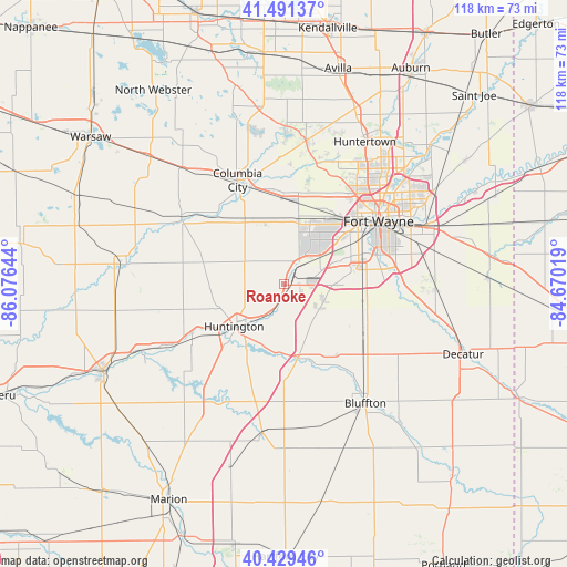
Roanoke GPS coordinates[2]
40° 57' 45.18" North, 85° 22' 23.916" West
| Map corner | latitude | longitude |
|---|---|---|
| Upper-left | 41.49137°, | -86.07644° |
| Center: | 40.96255°, | -85.37331° |
| Lower-right: | 40.42946°, | -84.67019° |
| Map W x H: | 118.1×118.1 km | = 73.4×73.4mi |
| max Lat: | 71.29058° ⇑34.5% North |
| Roanoke: | 40.96255° |
| min Lat: | ⇓65.5% South 19.06759° |
| min Long | Roanoke | max Long |
| -171.73463° | -85.37331° | -66.98998° |
| W 54.9%⇐ | ⇒45.1% E |
Elevation
Elevation of Roanoke is 233 m = 764 ft, and this is 61.8 m = 203 ft below average elevation for this country.
| Max E: |
3189 m = 10463 ft | 41.4% |
| Avg. | 294.8 m = 967 ft | |
| Roanoke | 233 m = 764 ft | |
Min E: |
-60 m = -197 ft | 58.6% |
See also: United States elevation on elevation.city.
Geographical zone
Roanoke is located in North temperate zone (between Tropic of Cancer and the Arctic Circle). Distance of this Northern Tropic circle is 1948.7 km =1210.9 mi to South.| Distance of | km | miles | from Roanoke |
|---|---|---|---|
| North Pole | 5452.5 | 3388 | to North |
| Arctic Circle | 2846.6 | 1768.8 | to North |
| Tropic Cancer | 1948.7 | 1210.9 | to South |
| Equator | 4554.6 | 2830.1 | to South |


Nearby cities:
15 places around Roanoke: (largest is in red/bold)
• Andrews
22.2 km =13.8 mi,  239°
239°
• Bluffton
30.1 km =18.7 mi,  145°
145°
• Churubusco
30.1 km =18.7 mi,  8°
8°
• Columbia City
23.7 km =14.7 mi,  335°
335°
• Fort Wayne
27.7 km =17.2 mi,  47°
47°
• Hoagland
32.1 km =19.9 mi,  92°
92°
• Huntington
13.7 km =8.5 mi,  229°
229°
• Markle
15.6 km =9.7 mi,  169°
169°
• New Haven
32.4 km =20.1 mi,  68°
68°
• North Manchester
33.4 km =20.8 mi,  277°
277°
• Ossian
19.6 km =12.2 mi,  117°
117°
• South Whitley
25.3 km =15.7 mi,  302°
302°
• Tri-Lakes
32 km =19.9 mi,  349°
349°
• Warren
31.4 km =19.5 mi,  188°
188°
• Zanesville
9.3 km =5.8 mi, 122°
Sources, notices
• [Note1] Compared only with cities in United States existing in our database
• [Src1] Map data: © OpenStreetMap contributors (CC-BY-SA)
• [Src2] Other city data from geonames.org with taken over terms of usage.
• [Src3] Geographical zone / Annual Mean Temperature by Robert A. Rohde @ Wikipedia
