Manchester-by-the-Sea geodata
Manchester-by-the-Sea (Massachusetts) is a populated place; located in United States in America/New_York (GMT-4) time zone. With population of 5,366 people, there are 6866 cities with bigger population in this country. Compared to other cities in United States, 80.4% of cities are located further ↓South; 98.1% of cities are located further ←West and 93.9% of cities have higher elevation than Manchester-by-the-Sea. Note1
Administrative division(s):
- Level 1: Massachusetts
- Level 2: Essex County
- Level 3: Town of Manchester-by-the-Sea


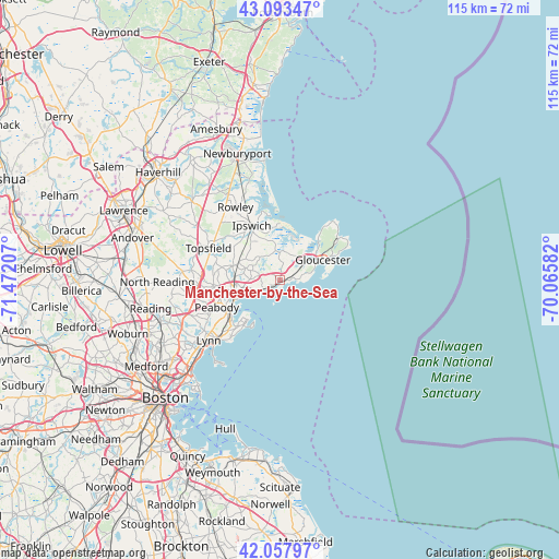
Manchester-by-the-Sea GPS coordinates[2]
42° 34' 40.332" North, 70° 46' 8.184" West
| Map corner | latitude | longitude |
|---|---|---|
| Upper-left | 43.09347°, | -71.47207° |
| Center: | 42.57787°, | -70.76894° |
| Lower-right: | 42.05797°, | -70.06582° |
| Map W x H: | 115.1×115.1 km | = 71.5×71.5mi |
| max Lat: | 71.29058° ⇑19.6% North |
| Manchester-by-the-Sea: | 42.57787° |
| min Lat: | ⇓80.4% South 19.06759° |
| min Long | Manchester-by-t | max Long |
| -171.73463° | -70.76894° | -66.98998° |
| W 98.1%⇐ | ⇒1.9% E |
Elevation
Elevation of Manchester-by-the-Sea is 10 m = 33 ft, and this is 284.8 m = 934 ft below average elevation for this country.
| Max E: |
3189 m = 10463 ft | 93.9% |
| Avg. | 294.8 m = 967 ft | |
| Manchester-by-the-Sea | 10 m = 33 ft | |
Min E: |
-60 m = -197 ft | 6.1% |
See also: United States elevation on elevation.city.
Geographical zone
Manchester-by-the-Sea is located in North temperate zone (between Tropic of Cancer and the Arctic Circle). Distance of this Northern Tropic circle is 2128.3 km =1322.5 mi to South.| Distance of | km | miles | from Manchester-by-the-Sea |
|---|---|---|---|
| North Pole | 5272.8 | 3276.4 | to North |
| Arctic Circle | 2667 | 1657.2 | to North |
| Tropic Cancer | 2128.3 | 1322.5 | to South |
| Equator | 4734.2 | 2941.7 | to South |


Nearby cities:
15 places around Manchester-by-the-Sea: (largest is in red/bold)
• Beverly
9.4 km =5.8 mi,  256°
256°
• Beverly Cove
7.5 km =4.7 mi,  248°
248°
• Danvers
13.2 km =8.2 mi,  268°
268°
• Essex
6.1 km =3.8 mi,  349°
349°
• Gloucester
9.5 km =5.9 mi,  65°
65°
• Ipswich
12.7 km =7.9 mi,  332°
332°
• Marblehead
11.3 km =7 mi,  220°
220°
• Peabody
14.2 km =8.8 mi, 246°
• Rockport
14.9 km =9.3 mi,  54°
54°
• Rowley
17.9 km =11.1 mi, 329°
• Salem
12.3 km =7.6 mi,  238°
238°
• South Peabody
16.6 km =10.3 mi, 242°
• Swampscott
17 km =10.6 mi,  225°
225°
• Topsfield
16.2 km =10.1 mi,  294°
294°
• Wenham
10.4 km =6.5 mi, 286°
Sources, notices
• [Note1] Compared only with cities in United States existing in our database
• [Src1] Map data: © OpenStreetMap contributors (CC-BY-SA)
• [Src2] Other city data from geonames.org with taken over terms of usage.
• [Src3] Geographical zone / Annual Mean Temperature by Robert A. Rohde @ Wikipedia
