Rockport geodata
Rockport (Massachusetts) is a populated place; located in United States in America/New_York (GMT-4) time zone. With population of 4,966 people, there are 7214 cities with bigger population in this country. Compared to other cities in United States, 81% of cities are located further ↓South; 98.3% of cities are located further ←West and 89.1% of cities have higher elevation than Rockport. Note1


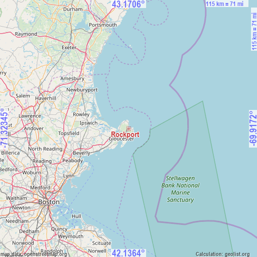
Rockport GPS coordinates[2]
42° 39' 20.34" North, 70° 37' 13.152" West
| Map corner | latitude | longitude |
|---|---|---|
| Upper-left | 43.1706°, | -71.32345° |
| Center: | 42.65565°, | -70.62032° |
| Lower-right: | 42.1364°, | -69.9172° |
| Map W x H: | 115×115 km | = 71.5×71.5mi |
| max Lat: | 71.29058° ⇑19% North |
| Rockport: | 42.65565° |
| min Lat: | ⇓81% South 19.06759° |
| min Long | Rockport | max Long |
| -171.73463° | -70.62032° | -66.98998° |
| W 98.3%⇐ | ⇒1.7% E |
Elevation
Elevation of Rockport is 18 m = 59 ft, and this is 276.8 m = 908 ft below average elevation for this country.
| Max E: |
3189 m = 10463 ft | 89.1% |
| Avg. | 294.8 m = 967 ft | |
| Rockport | 18 m = 59 ft | |
Min E: |
-60 m = -197 ft | 10.9% |
See also: United States elevation on elevation.city.
Geographical zone
Rockport is located in North temperate zone (between Tropic of Cancer and the Arctic Circle). Distance of this Northern Tropic circle is 2136.9 km =1327.8 mi to South.| Distance of | km | miles | from Rockport |
|---|---|---|---|
| North Pole | 5264.2 | 3271 | to North |
| Arctic Circle | 2658.3 | 1651.8 | to North |
| Tropic Cancer | 2136.9 | 1327.8 | to South |
| Equator | 4742.9 | 2947.1 | to South |


Nearby cities:
15 places around Rockport: (largest is in red/bold)
• Beverly
23.8 km =14.8 mi,  243°
243°
• Beverly Cove
22.2 km =13.8 mi, 239°
• Danvers
26.9 km =16.7 mi,  250°
250°
• Essex
13.5 km =8.4 mi,  258°
258°
• Gloucester
5.8 km =3.6 mi,  217°
217°
• Ipswich
18.2 km =11.3 mi,  278°
278°
• Manchester-by-the-Sea
14.9 km =9.3 mi,  234°
234°
• Marblehead
26 km =16.2 mi, 228°
• Newburyport
27.3 km =17 mi,  309°
309°
• Peabody
29 km =18 mi, 240°
• Rowley
22.2 km =13.8 mi,  287°
287°
• Salem
27.2 km =16.9 mi, 236°
• Salisbury
28.5 km =17.7 mi,  316°
316°
• Topsfield
27 km =16.8 mi,  265°
265°
• Wenham
22.9 km =14.2 mi, 255°
Sources, notices
• [Note1] Compared only with cities in United States existing in our database
• [Src1] Map data: © OpenStreetMap contributors (CC-BY-SA)
• [Src2] Other city data from geonames.org with taken over terms of usage.
• [Src3] Geographical zone / Annual Mean Temperature by Robert A. Rohde @ Wikipedia
