Livonia geodata
Livonia (Michigan) is a populated place; located in United States in America/Detroit (GMT-4) time zone. With population of 94,635 people, there are 380 cities with bigger population in this country. Compared to other cities in United States, 78.7% of cities are located further ↓South; 61% of cities are located further ←West and 50.3% of cities have higher elevation than Livonia. Note1


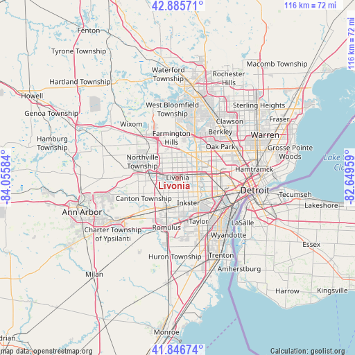
Livonia GPS coordinates[2]
42° 22' 6.132" North, 83° 21' 9.756" West
| Map corner | latitude | longitude |
|---|---|---|
| Upper-left | 42.88571°, | -84.05584° |
| Center: | 42.36837°, | -83.35271° |
| Lower-right: | 41.84674°, | -82.64959° |
| Map W x H: | 115.5×115.5 km | = 71.8×71.8mi |
| max Lat: | 71.29058° ⇑21.3% North |
| Livonia: | 42.36837° |
| min Lat: | ⇓78.7% South 19.06759° |
| min Long | Livonia | max Long |
| -171.73463° | -83.35271° | -66.98998° |
| W 61%⇐ | ⇒39% E |
Elevation
Elevation of Livonia is 197 m = 646 ft, and this is 97.8 m = 321 ft below average elevation for this country.
| Max E: |
3189 m = 10463 ft | 50.3% |
| Avg. | 294.8 m = 967 ft | |
| Livonia | 197 m = 646 ft | |
Min E: |
-60 m = -197 ft | 49.7% |
See also: Livonia elevation on elevation.city.
Geographical zone
Livonia is located in North temperate zone (between Tropic of Cancer and the Arctic Circle). Distance of this Northern Tropic circle is 2105 km =1308 mi to South.| Distance of | km | miles | from Livonia |
|---|---|---|---|
| North Pole | 5296.1 | 3290.8 | to North |
| Arctic Circle | 2690.3 | 1671.7 | to North |
| Tropic Cancer | 2105 | 1308 | to South |
| Equator | 4710.9 | 2927.2 | to South |


Nearby cities:
15 places around Livonia: (largest is in red/bold)
• Canton
12.5 km =7.8 mi,  238°
238°
• Dearborn
15.4 km =9.6 mi,  109°
109°
• Dearborn Heights
7.4 km =4.6 mi,  118°
118°
• Farmington
10.9 km =6.8 mi,  349°
349°
• Farmington Hills
13.2 km =8.2 mi, 351°
• Garden City
5.1 km =3.2 mi,  159°
159°
• Inkster
9 km =5.6 mi, 156°
• Northville
12.8 km =8 mi,  303°
303°
• Novi
16 km =9.9 mi,  321°
321°
• Plymouth
9.7 km =6 mi,  272°
272°
• Redford
4.9 km =3 mi,  70°
70°
• Southfield
15.9 km =9.9 mi,  42°
42°
• Taylor
15.7 km =9.8 mi,  154°
154°
• Wayne
10.1 km =6.3 mi,  195°
195°
• Westland
6.3 km =3.9 mi,  218°
218°
Sources, notices
• [Note1] Compared only with cities in United States existing in our database
• [Src1] Map data: © OpenStreetMap contributors (CC-BY-SA)
• [Src2] Other city data from geonames.org with taken over terms of usage.
• [Src3] Geographical zone / Annual Mean Temperature by Robert A. Rohde @ Wikipedia
