Shelby geodata
Shelby (Michigan) is a populated place; located in United States in America/Detroit (GMT-4) time zone. With population of 74,099 people, there are 553 cities with bigger population in this country. Compared to other cities in United States, 81% of cities are located further ↓South; 61.9% of cities are located further ←West and 53% of cities have lower elevation than Shelby. Note1
Administrative division(s):
- Level 1: Michigan
- Level 2: Macomb County
- Level 3: Charter Township of Shelby


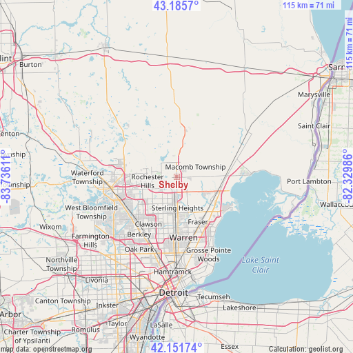
Shelby GPS coordinates[2]
42° 40' 15.132" North, 83° 1' 58.728" West
| Map corner | latitude | longitude |
|---|---|---|
| Upper-left | 43.1857°, | -83.73611° |
| Center: | 42.67087°, | -83.03298° |
| Lower-right: | 42.15174°, | -82.32986° |
| Map W x H: | 115×115 km | = 71.5×71.5mi |
| max Lat: | 71.29058° ⇑19% North |
| Shelby: | 42.67087° |
| min Lat: | ⇓81% South 19.06759° |
| min Long | Shelby | max Long |
| -171.73463° | -83.03298° | -66.98998° |
| W 61.9%⇐ | ⇒38.1% E |
Elevation
Elevation of Shelby is 210 m = 689 ft, and this is 84.8 m = 278 ft below average elevation for this country.
| Max E: |
3189 m = 10463 ft | 47% |
| Avg. | 294.8 m = 967 ft | |
| Shelby | 210 m = 689 ft | |
Min E: |
-60 m = -197 ft | 53% |
See also: Shelby elevation on elevation.city.
Geographical zone
Shelby is located in North temperate zone (between Tropic of Cancer and the Arctic Circle). Distance of this Northern Tropic circle is 2138.6 km =1328.9 mi to South.| Distance of | km | miles | from Shelby |
|---|---|---|---|
| North Pole | 5262.5 | 3270 | to North |
| Arctic Circle | 2656.6 | 1650.7 | to North |
| Tropic Cancer | 2138.6 | 1328.9 | to South |
| Equator | 4744.6 | 2948.2 | to South |


Nearby cities:
15 places around Shelby: (largest is in red/bold)
• Auburn Hills
16.5 km =10.3 mi,  276°
276°
• Birmingham
20.1 km =12.5 mi,  226°
226°
• Bloomfield Hills
19.9 km =12.4 mi,  240°
240°
• Clawson
17.9 km =11.1 mi,  211°
211°
• Clinton Township
13.1 km =8.1 mi,  135°
135°
• Fraser
16.2 km =10.1 mi,  154°
154°
• Mount Clemens
15.1 km =9.4 mi,  122°
122°
• New Haven
20 km =12.4 mi,  71°
71°
• Rochester
8.3 km =5.2 mi, 277°
• Rochester Hills
9.7 km =6 mi,  261°
261°
• Romeo
14.8 km =9.2 mi,  6°
6°
• Sterling Heights
10.1 km =6.3 mi,  178°
178°
• Troy
12 km =7.5 mi, 232°
• Utica
5 km =3.1 mi, 180°
• Warren
20.1 km =12.5 mi, 175°
Sources, notices
• [Note1] Compared only with cities in United States existing in our database
• [Src1] Map data: © OpenStreetMap contributors (CC-BY-SA)
• [Src2] Other city data from geonames.org with taken over terms of usage.
• [Src3] Geographical zone / Annual Mean Temperature by Robert A. Rohde @ Wikipedia
