Utica geodata
Utica (Michigan) is a populated place; located in United States in America/Detroit (GMT-4) time zone. With population of 4,942 people, there are 7241 cities with bigger population in this country. Compared to other cities in United States, 80.8% of cities are located further ↓South; 61.9% of cities are located further ←West and 50.2% of cities have lower elevation than Utica. Note1


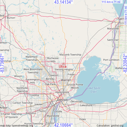
Utica GPS coordinates[2]
42° 37' 34.104" North, 83° 2' 0.744" West
| Map corner | latitude | longitude |
|---|---|---|
| Upper-left | 43.14134°, | -83.73667° |
| Center: | 42.62614°, | -83.03354° |
| Lower-right: | 42.10664°, | -82.33042° |
| Map W x H: | 115×115 km | = 71.5×71.5mi |
| max Lat: | 71.29058° ⇑19.2% North |
| Utica: | 42.62614° |
| min Lat: | ⇓80.8% South 19.06759° |
| min Long | Utica | max Long |
| -171.73463° | -83.03354° | -66.98998° |
| W 61.9%⇐ | ⇒38.1% E |
Elevation
Elevation of Utica is 199 m = 653 ft, and this is 95.8 m = 314 ft below average elevation for this country.
| Max E: |
3189 m = 10463 ft | 49.8% |
| Avg. | 294.8 m = 967 ft | |
| Utica | 199 m = 653 ft | |
Min E: |
-60 m = -197 ft | 50.2% |
See also: United States elevation on elevation.city.
Geographical zone
Utica is located in North temperate zone (between Tropic of Cancer and the Arctic Circle). Distance of this Northern Tropic circle is 2133.7 km =1325.8 mi to South.| Distance of | km | miles | from Utica |
|---|---|---|---|
| North Pole | 5267.5 | 3273.1 | to North |
| Arctic Circle | 2661.6 | 1653.8 | to North |
| Tropic Cancer | 2133.7 | 1325.8 | to South |
| Equator | 4739.6 | 2945 | to South |


Nearby cities:
15 places around Utica: (largest is in red/bold)
• Birmingham
17 km =10.6 mi,  238°
238°
• Center Line
15.7 km =9.8 mi,  178°
178°
• Clawson
13.8 km =8.6 mi,  221°
221°
• Clinton Township
10.3 km =6.4 mi,  115°
115°
• Fraser
11.9 km =7.4 mi,  144°
144°
• Madison Heights
16.7 km =10.4 mi,  200°
200°
• Mount Clemens
13.1 km =8.1 mi,  104°
104°
• Rochester
10.2 km =6.3 mi,  306°
306°
• Rochester Hills
10.2 km =6.3 mi,  290°
290°
• Roseville
16.4 km =10.2 mi,  151°
151°
• Royal Oak
17.7 km =11 mi,  210°
210°
• Shelby
5 km =3.1 mi,  0°
0°
• Sterling Heights
5.1 km =3.2 mi, 176°
• Troy
9.8 km =6.1 mi,  256°
256°
• Warren
15.2 km =9.4 mi,  173°
173°
Sources, notices
• [Note1] Compared only with cities in United States existing in our database
• [Src1] Map data: © OpenStreetMap contributors (CC-BY-SA)
• [Src2] Other city data from geonames.org with taken over terms of usage.
• [Src3] Geographical zone / Annual Mean Temperature by Robert A. Rohde @ Wikipedia
