Westphalia geodata
Westphalia (Michigan) is a populated place; located in United States in America/Detroit (GMT-4) time zone. With population of 937 people, there are 16738 cities with bigger population in this country. Compared to other cities in United States, 82.7% of cities are located further ↓South; 56.3% of cities are located further ←West and 58.2% of cities have lower elevation than Westphalia. Note1
Administrative division(s):
- Level 1: Michigan
- Level 2: Clinton County
- Level 3: Township of Westphalia


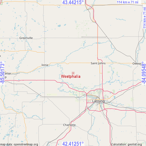
Westphalia GPS coordinates[2]
42° 55' 46.128" North, 84° 47' 54.96" West
| Map corner | latitude | longitude |
|---|---|---|
| Upper-left | 43.44215°, | -85.50173° |
| Center: | 42.92948°, | -84.7986° |
| Lower-right: | 42.41251°, | -84.09548° |
| Map W x H: | 114.5×114.5 km | = 71.1×71.1mi |
| max Lat: | 71.29058° ⇑17.3% North |
| Westphalia: | 42.92948° |
| min Lat: | ⇓82.7% South 19.06759° |
| min Long | Westphalia | max Long |
| -171.73463° | -84.7986° | -66.98998° |
| W 56.3%⇐ | ⇒43.7% E |
Elevation
Elevation of Westphalia is 231 m = 758 ft, and this is 63.8 m = 209 ft below average elevation for this country.
| Max E: |
3189 m = 10463 ft | 41.8% |
| Avg. | 294.8 m = 967 ft | |
| Westphalia | 231 m = 758 ft | |
Min E: |
-60 m = -197 ft | 58.2% |
See also: United States elevation on elevation.city.
Geographical zone
Westphalia is located in North temperate zone (between Tropic of Cancer and the Arctic Circle). Distance of this Northern Tropic circle is 2167.4 km =1346.8 mi to South.| Distance of | km | miles | from Westphalia |
|---|---|---|---|
| North Pole | 5233.8 | 3252.1 | to North |
| Arctic Circle | 2627.9 | 1632.9 | to North |
| Tropic Cancer | 2167.4 | 1346.8 | to South |
| Equator | 4773.3 | 2966 | to South |


Nearby cities:
15 places around Westphalia: (largest is in red/bold)
• Carson City
27.8 km =17.3 mi,  351°
351°
• DeWitt
21.1 km =13.1 mi,  117°
117°
• Edgemont Park
26.3 km =16.3 mi,  140°
140°
• Fowler
9.4 km =5.8 mi,  30°
30°
• Grand Ledge
20 km =12.4 mi,  167°
167°
• Ionia
23.1 km =14.4 mi,  286°
286°
• Lyons
13.4 km =8.3 mi,  295°
295°
• Maple Rapids
21.3 km =13.2 mi,  23°
23°
• Muir
13.8 km =8.6 mi, 302°
• Mulliken
20.2 km =12.6 mi,  203°
203°
• Portland
10.8 km =6.7 mi,  231°
231°
• Saint Johns
21 km =13 mi,  67°
67°
• Sunfield
24.4 km =15.2 mi,  220°
220°
• Wacousta
13.8 km =8.6 mi, 144°
• Waverly
25.6 km =15.9 mi,  145°
145°
Sources, notices
• [Note1] Compared only with cities in United States existing in our database
• [Src1] Map data: © OpenStreetMap contributors (CC-BY-SA)
• [Src2] Other city data from geonames.org with taken over terms of usage.
• [Src3] Geographical zone / Annual Mean Temperature by Robert A. Rohde @ Wikipedia
